Hoosiers should not expect relief from the heat this week.
Jason Puma, meteorologist at the National Weather Service in Indianapolis, said changes in the weather pattern causing a heat wave aren’t expected until sometime early next week.
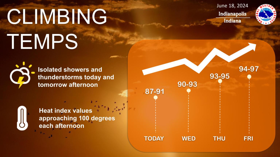
It’s common for Indiana to see temperatures in the 90s, Puma said, and no heat records have been broken by the weather so far. Later this week, however, temperatures could hit the mid- to high-90s, which would flirt with records at that point.
What’s causing Indiana’s heat wave?
There’s a strong area of high pressure over the East Coast, Puma said. This allows much warmer air from the south and southwest to be pushed up into the Ohio Valley and Great Lakes regions.
“A lot of this air originated from points in the American Southwest where they had temperatures in the 100s late last week, and it’s moved eastward into our neck of the woods here,” Puma said.
Patterns keeping warm air in Indiana
That high pressure area is working in tandem with what Puma called a “strong ridge axis” in the upper level of the atmosphere. He explained that the atmosphere is like waves at bottom of a river with the ridge axis as a high point.
The ridge steers that warm our direction, which prevents the high-pressure system from moving anywhere.
What will it take to break Indiana’s heat?
Meteorologists like Puma are watching for a change in the weather pattern where the upper ridgin breaks down.
“Once that does occur, the flow will change from the southwest to a more westerly or northwesterly flow, and that will help to usher the high pressure system away and give us cooler air arriving in the area,” Puma said.
Indiana heat wave: Here’s how to stay safe and comfortable in the summer
Will the rain cool things off?
Scattered storms Tuesday and Wednesday, along with the expected cloud cover, will help keep things a bit cooler, but Puma said Indiana will see mostly dry weather for the rest of the week.
“However, as we see (Tuesday) and even (Wednesday), there’s a warm and humid airmass in place,” Puma said. “We can’t rule out a few isolated showers or perhaps a thunderstorm here and there.”
NWS safety tips for the heat
Puma advised Hoosiers to limit their outdoor activities to the cooler times of the day, mainly mornings and evenings.
“If you must be outside during the hottest hours of the day, you probably want to make sure that you take frequent breaks and hydrate often,” Puma said. “Check up on the elderly, children and pets ― those are the people and animals that could be mostly impacted by the heat.”
Karl Schneider is an IndyStar environment reporter. You can reach him at karl.schneider@indystar.com. Follow him on Twitter @karlstartswithk
IndyStar’s environmental reporting project is made possible through the generous support of the nonprofit Nina Mason Pulliam Charitable Trust.
This article originally appeared on Indianapolis Star: Indiana heat wave expected through early next week. Here’s how it will end
Signup bonus from