Nashville and surrounding areas were blanketed with record breaking snowfall during the week of Jan. 14, but what are the chances of Music City receiving more snow this winter?
With seven to eight weeks of the winter season remaining, there’s still a possibility for another winter weather event said National Weather Service Meteorologist Krissy Hurley.
According to Hurley, the current pattern appears to be more favorable for typical winter season weather in mid to late February. “By March, we typically start getting warmer as the weeks progress although a late winter system or at the very least, a late spring frost or freeze is never out of the question,” she said.
Main snow months are January and February however there is still a possibility for more snow events heading into March.
Additionally, 2023 is an El Niño year, which means more opportunities for wintry weather if the cold arctic air can make it to Tennessee since the jet stream is usually further south and active across the southern half of the U.S., Hurley told the Tennessean back in December.
Although experiencing multiple major snow events in the same season is unusual, the possibility can’t be ruled out said Hurley.
“Especially considering we’re in an El Nino where we typically see a more active weather pattern due to a more southerly jet stream,” added Hurley.
More: First snow of 2024 blankets Nashville area as frigid weather settles in across Middle Tennessee
What will Nashville weather look like in mid February?
In the short term, conditions are looking like above normal for temperatures and precipitation through mid February, said Hurley.
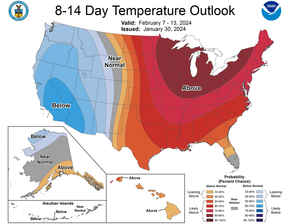
According to the weather service, increased chances for above-normal temperatures are predicted across much of the central and eastern conterminous United States. The highest probabilities (greater than 90%) are focused across the Great Lakes region. Probabilities for above-normal temperatures decrease across the Southern Tier.
During this time frame (Feb. 8 – Feb. 14) Middle Tennessee will likely have slightly above normal precipitation.
What will Nashville weather look like in late February?
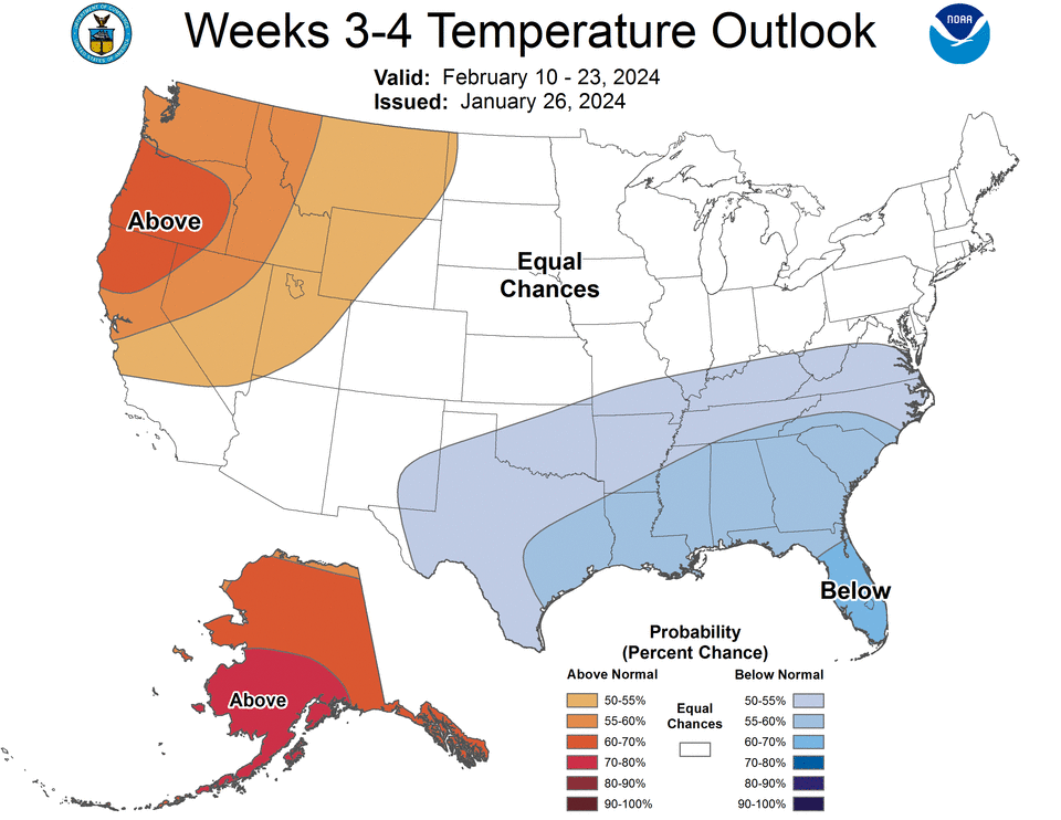
The weather service said El Niño conditions currently display above average sea surface temperatures across the central and eastern tropical Pacific Ocean.
The temperature outlook predicts enhanced probabilities of above normal temperatures over much of the western conterminous U.S. In Middle Tennessee, temperatures are predicted to be below normal.
During this time frame (Feb. 10 – Feb. 23) Middle Tennessee will have an equal chance of precipitation.
Record snowfall in Nashville
According to the weather service, the highest winter snowfall occurred between 1959 and 1960, when the city received nearly 39 inches of snow.
Nashville’s top five snowstorms:
-
March 17-18, 1892: 17 inches
-
February, 2-3, 1886: 16 inches
-
February 19-20, 1929: 15 inches
-
December 31-Jan. 1, 1964: 10 inches
-
January 31-Feb. 1, 1951: 10 inches
Diana Leyva covers trending news and service for The Tennessean. Contact her at Dleyva@gannett.com or follow her on X, the platform formerly known as Twitter at @_leyvadiana
This article originally appeared on Nashville Tennessean: Nashville weather: Will it snow again this winter? What to know
Signup bonus from