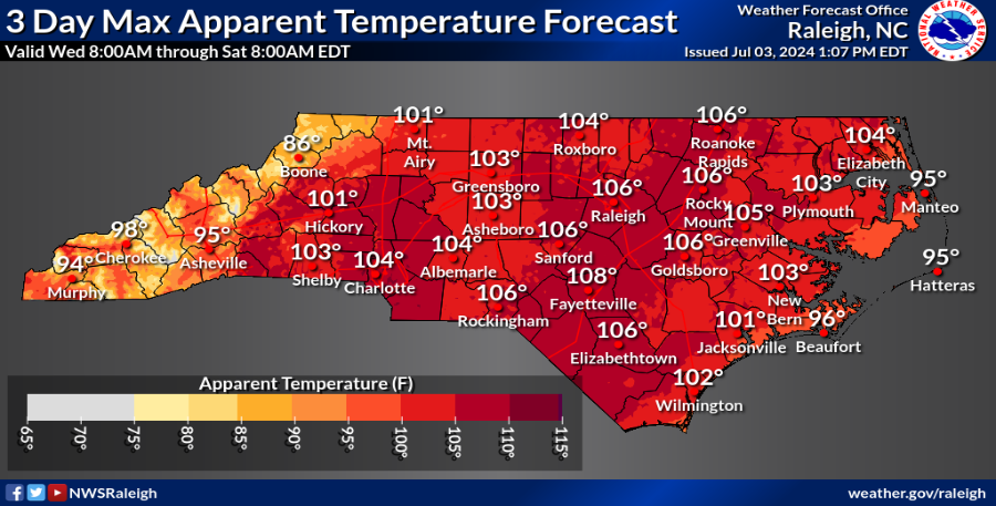
Here’s one of my favorite bits of Fayetteville weather trivia: It has NEVER reached 100 degrees on the Fourth here. The record is 98, set in 2019.
Fayetteville may well reach that mark on the Fourth this time around, with some modeling pushing other spots in the Cape Fear region to 100 degrees. We also have a slight chance of isolated popcorn showers, but no real threat to Independence Day events.
It’s part of a continuing pattern that will run into the weekend. After that, we’ll see an increased chance of rain and slightly cooler temperatures.
Here’s the setup
The Canadian high pressure that made the last couple of days so pleasant has slipped offshore. In its place, a much warmer, more humid air mass is moving in from the south and west.
Temperatures will climb quickly Thursday, with highs in the upper 90s and dew points above 70. That’s not quite enough for official heat advisories, but sunscreen, shade and lots of drinks are a good idea for any outdoor activities.
Right now, the chances of showers look scant. The best chance for any afternoon and evening popcorn showers will be well to the north of the region, with a few popping up along the Sea Breeze line. In all, it looks like a good night for free entertainment and fireworks Thursday night in Festival Park.
Other celebrations in the area include Lillington, Aberdeen, Sanford, Lumberton, Clinton, Wade and White Lake. Temperatures at dusk will still be warm, in the mid- to upper 80s across the Cape Fear region.
Friday will be a bit warmer as the heat ridge builds over the region. It looks like some 100-degree marks will be set both Friday and Saturday, with heat advisories likely on both days. Lows will be near “high-low” records in the mid- to upper 70s. Shower chances increase slightly, but we won’t see anything widespread.
The weekend
There’s a decent chance Fayetteville sets another heat record on Saturday as temperatures climb into triple digits. Later on, shower chances increase across the region as a disturbance tracks to our north.
In addition, some modeling projects a weak offshore system spinning up toward the weekend. This would enhance moisture, increasing rain chances. Lows remain in the mid- to upper 70s.
Down the road
Things become more seasonal, with highs in the low 90s and occasional packets of energy crossing the region to enhance rain chances. Highs in Fayetteville should reach the low 90s, depending on shower activity through much of next week.
In the tropics
All eyes are on Beryl as it churns toward the Yucatan Peninsula. After that, steering currents will guide it either into Mexico or Texas late Sunday or early Monday. Another disturbance deep in the Caribbean is getting ripped up by shear and shouldn’t be an issue.
After that, desert dust moves into the region, which should choke and potential storm formation.
Stay cool, and have a happy Fourth!
Got a weather question Chick Jacobs can be reached at ncweatherhound@gmail.com of NCWeatherhound on X/Twitter.
This article originally appeared on The Fayetteville Observer: What is the weather forecast in Fayetteville on the Fourth of July?
Signup bonus from