Tuesday night’s upward of 5 inches of rain brought flooding to a couple of locations in Boone County on Wednesday, said Chris Kelly, director of the office of emergency management.
The main main message he had Wednesday, though, since more rain was forecast for the day and Thursday, is “turn around, don’t drown.”
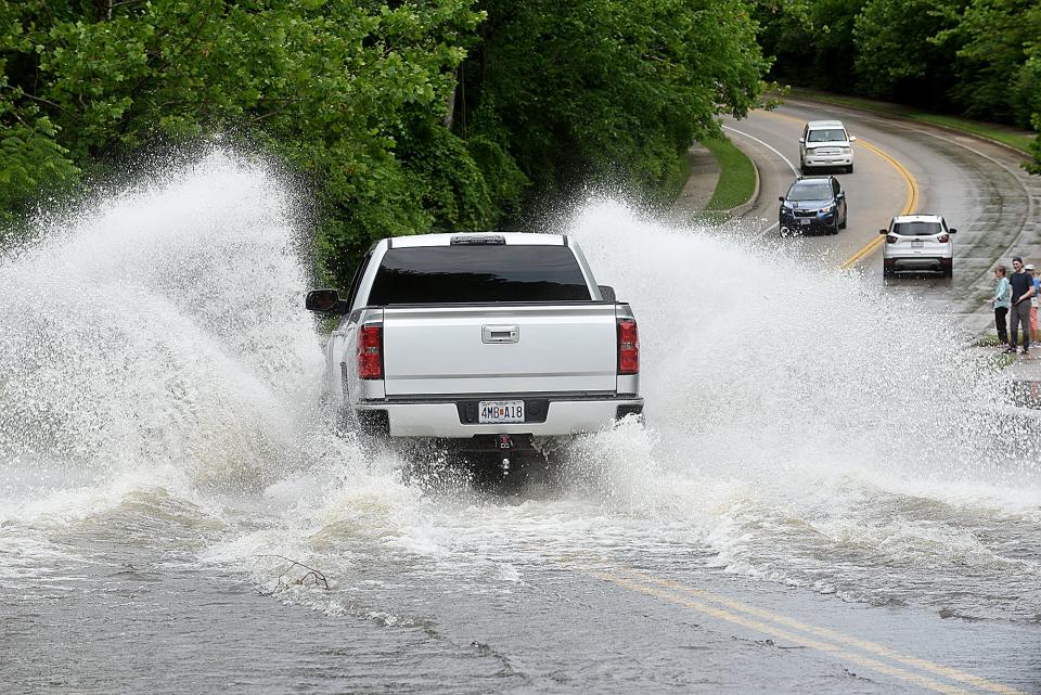
“Our road and bridge department has put out signage to not go through the water,” Kelly said. “It only takes 12 inches of water to move a vehicle if it is (flowing). Even if it is not, pooling water can cause performance issues for (vehicle) engines and people get stuck in that water.”
Pooling or moving water also can hide roadway washouts, he added.
Some bike and pedestrian trails also are flooded, noted Tammy Miller, with Columbia Parks and Recreation, in a message to the Tribune.
“The MKT Trail is impassable in some areas, particularly between the MLK/Stadium access and Jay Dix Station,” she wrote. “The entry road at Twin Lakes at the roundabout is flooded. The County House Trail is impassable. Magnolia Falls Park is experiencing some flooding and Strawn Park is also experiencing flooding. We encourage park and trail users to not enter trail sections where flooding has occurred.”
Parks and Recreation staff were out Wednesday evaluating areas, Miller added.
Roadway flooding was seen in the areas of Wilcox Road at Route E (Stadium Boulevard) and Easley River Road at Cooper’s Landing on Wednesday, Kelly said.
Forecasts are not enough, though, for sandbag operations, he added. The Missouri River flood stage is 21 feet at Boonville and while there was minor flooding associated with Tuesday’s rain, the river still was expected to crest at 25 feet by 7 p.m. Friday. Moderate flooding at the Hinkson Creek already has crested at 19 feet and was expected to go down again despite the forecasted rain Wednesday and Thursday. The creek’s flood stage is 15 feet.
Flooding becomes more of a significant concern when it hits 30 feet at Rocheport, Kelly said.
“We’re not going to be close to that based on the National Weather Service forecast. Hartsburg is 27 feet and we’re not going to be there based on the forecast models. We’ve alerted all our partners along the river as far as government entities and small towns. We have even reached out to the owner of Cooper’s Landing about the potential flooding,” he said.
More: Columbia forecast could put a damper on July 4 activities. Here’s what to know
With Hinkson Creek flooding, the trouble usually is when it hits 20 feet, he added, and the last time it was above that level was June 25, 2021, when it crested at 23.45 feet, a record breaker.
“That is when we got about 12 inches of rain in less than 24 hours,” Kelly said, adding flooding then closed Providence Road south of the Mizzou Arena and near Research Park Drive.
Some other locales that can have roadway flooding include North Strawn Road off West Broadway and Blackfoot Road, which crosses Bear Creek. These were expected to go down by the evening hours Wednesday, Kelly said.
“Our focal point now is just along the river … and we also worried about the few residents in McBaine. We are working with the sheriff’s department to communicate with them about (Perche) Creek there backing up from the river flow,” he said. “We’ll see what this evening we get precipitation wise.”
A traveler information map from the Missouri Department of Transportation noted flooding-related closures at Route CC in Centralia, which crosses paths with Long Branch and Goodwater Creek; Route Z west of New Franklin; Route P northeast of New Franklin, crossing paths with Salt Creek; and Route A at the Moniteau Creek Conservation Area southeast of Fayette.
August 2023: Heavy rains impact some streets, parks with early morning flooding
Northern Boone, Callaway and southern Audrain counties remained under a flash flood warning until 8:30 p.m. Wednesday.
Gov. Mike Parson extended a May emergency declaration June 26 due to the potential of Missouri River flooding after recent storms.
“We have seen the tremendous, destructive force of flooding this past week in neighboring states to our north and must ensure resources are available should flooding threaten areas of our state,” Parson said. “This extension allows us to be ready to respond and support our communities. We encourage Missourians to follow their local forecasts and have preparations in place to protect themselves and their loved ones.”
Charles Dunlap covers local government, community stories and other general subjects for the Tribune. You can reach him at cdunlap@columbiatribune.com or @CD_CDT on X, formerly Twitter. Subscribe to support vital local journalism.
This article originally appeared on Columbia Daily Tribune: Rain causes flooding around Boone County, with some creeks cresting
Signup bonus from