Hurricane Beryl exploded overnight, growing into a Category 5 hurricane with 165-mph winds, according to the 2 a.m. advisory from the National Hurricane Center.
And it’s still intensifying.
When it made landfall at 11 a.m. on Carriacou Island Monday, July 1, it was a Category 4 storm with 150-mph winds.
Forecasters said Beryl is expected to bring “life-threatening winds and storm surge to Jamaica later this week.”
The next appreciable landmass in Beryl’s path will be Jamaica on Wednesday,” AccuWeather Lead Tropical Meteorologist Alex DaSilva said. “Jamaica is likely to experience a high risk to lives and property Wednesday.”
Factors affecting Beryl’s intensity include much warmer-than-historical-average waters and wind shear, according to AccuWeather forecasters. If wind shear is strong enough, it can lead to weakening of tropical systems. Warm water helps storms develop and intensify.
DaSilva said water temperatures in early July are equal to what they usually are in late August, early September.
“Even if Beryl loses some wind intensity during the second half of the week, it will remain a dangerous hurricane with the likelihood of torrential rain, flooding, mudslides, damaging winds, pounding seas and storm surge along and near its path,” according to AccuWeather.
Hurricane Beryl sets record as earliest Category 5 storm on record
#HurricaneBeryl is now a Category 5 hurricane on the Saffir-Simpson hurricane wind scale per the NHC’s 11 p.m. advisory.
This is the earliest Category 5 hurricane on record, beating Emily’s record from 2005 by 15 days. pic.twitter.com/ldLW2skgWP
— WeatherTiger – weathertiger.substack.com (@wx_tiger) July 2, 2024
Beryl wasted no time in growing into a powerful hurricane.
The system making its way quickly across the Atlantic became a tropical depression Friday afternoon, a tropical storm by late Friday night and a hurricane about 24 hours later on Saturday.
By Sunday morning, Beryl had strengthened into a major Category 4 hurricane, with winds of 130 mph.
During landfall on Carriacou Island in Grenada at 11 a.m. Monday, it was a Category 4 storm with 150-mph winds.
Twelve hours later, it was a Category 5 storm with 160-mph winds.
Three hours later, at 2 a.m. Tuesday, it had strengthened again, with winds at 165 mph.
Its the earliest Category 5 storm on record, according to Dr. Ryan Truchelut, chief meteorologist at WeatherTiger. “This is the earliest Category 5 hurricane on record, beating Emily’s record from 2005 by 15 days.”
Truchelut works with the USA TODAY Network-Florida to provide the latest storm information Florida residents need.
Spaghetti models: Where will Hurricane Beryl go next?
Special note about spaghetti models: Illustrations include an array of forecast tools and models, and not all are created equal. The hurricane center uses only the top four or five highest performing models to help make its forecasts.
Will Hurricane Beryl impact Florida?
AccuWeather meteorologists currently don’t expect Beryl to impact Florida and the U.S., but warn residents to not let down their guard.
“At this point, the most likely scenario is for the storm to move westward into Mexico. However, it is very important to note that if the high pressure across the Southeast weakens, that can allow the storm to move farther north and potentially directly impact the Gulf Coast,” DaSilva said.
“Should the high pressure area remain strong, Beryl will make landfall in Belize or Mexico’s Yucatan Peninsula on Thursday night or Friday,” said AccuWeather Chief On-Air Meteorologist Bernie Rayno.
“But if the high weakens just a bit, it may allow Beryl to take a more northwesterly track, in which case it may avoid more land and get into the Gulf of Mexico as a formidable hurricane instead of a chopped-down tropical storm that encounters more land.”
Because of the potential for Beryl to turn more to the northwest upon reaching the northwestern Caribbean, residents in the U.S., especially the Texas coast, should closely monitor the hurricane’s progress and forecasts by meteorologists.
Beryl and July 4: Could Hurricane Beryl affect your Florida Fourth of July plans?
Watches, warnings issued across Florida
Hurricane Beryl: What you need to know
-
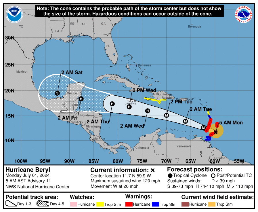
Location: 445 miles east-southeast of Isla Beata, Dominican Republic; 775 miles east-southeast of Kingston, Jamaica
-
Maximum sustained winds: 165 mph
-
Movement: West-northwest at 22 mph
-
Pressure: 935 mb
-
Next advisory: 5 a.m.
Watches and warnings issued for Hurricane Beryl
For an explanation of what the watches and warnings mean, scroll to the bottom of this story.
Hurricane warning: A hurricane warning is in effect for:
Tropical Storm Warning: A tropical storm warning is in effect for the following:
Hurricane Beryl ‘powerful’ Category 5 hurricane with 165-mph winds
At 2 a.m., the center of Hurricane Beryl was located near latitude 14.2 North, longitude 65.8 West.
Beryl is moving toward the west-northwest near 22 mph. Beryl is forecast to continue moving rapidly west-northwestward during the next couple of days.
On the forecast track, the center of Beryl will move quickly across the southeastern and central Caribbean Sea today and is forecast to pass near Jamaica on Wednesday.
Recent data from the NOAA Hurricane Hunters indicate maximum sustained winds have increased to near 165 mph, with higher gusts.
Beryl is a Category 5 hurricane on the Saffir-Simpson Hurricane Wind Scale.
Fluctuations in strength are likely during the next day or so, but Beryl is expected to still be near major hurricane intensity as its moves into the central Caribbean and passes near Jamaica on Wednesday.
Additional weakening is expected thereafter, though Beryl is forecast to remain a hurricane in the northwestern Caribbean.
Hurricane-force winds extend outward up to 40 miles from the center and tropical-storm-force winds extend outward up to 125 miles.
How strong is Hurricane Beryl and where is it going?
Key messages from the National Hurricane Center: What you need to know about Hurricane Beryl
-
Beryl is forecast to remain a powerful hurricane as it moves across the Caribbean Sea later this week. A Hurricane Warning is now in effect for Jamaica, where hurricane conditions are expected on Wednesday. A Tropical Storm Warning is also in effect for the south coast of Hispaniola.
-
Heavy rainfall and flash flooding are possible over portions of Jamaica on Wednesday.
-
Residents in the Cayman Islands, Belize, the Yucatan Peninsula, the remainder of the northwestern Caribbean, and the southwestern Gulf of Mexico should monitor the progress of Beryl. Additional watches and warnings will likely be required on Tuesday or Wednesday.
Current forecast: How strong is Hurricane Beryl expected to get?
-
Currently: 165 mph
-
12 hours: 155 mph
-
24 hours: 145 mph
-
36 hours: 120 mph
-
48 hours: 110 mph
-
60 hours: 100 mph
-
72 hours: 90 mph
-
96 hours: 65 mph
-
120 hours: 65 mph
What impact could Hurricane Beryl have and what areas could be affected?
-
WIND: Hurricane conditions are expected to reach the coast on Jamaica within the warning area on Wednesday. Winds are expected to first reach tropical storm strength early on Wednesday, making outside preparations difficult or dangerous.
-
STORM SURGE: Storm surge could raise water levels by as much as 3 to 5 feet above normal tide levels in areas of onshore winds along the immediate coast of Jamaica.
-
RAINFALL: Hurricane Beryl is expected to produce rainfall totals of 4 to 8 inches, with localized maxima of 12 inches, in portions of Jamaica on Wednesday. This rainfall may cause flash flooding in vulnerable areas. Rainfall from outer bands of Beryl may impact portions of Hispaniola today into Wednesday, with 2 to 6 inches of rain possible.
-
SURF: Large swells generated by Beryl will continue across the Windward and southern Leeward Islands during the next couple of days. Swells are also expected to reach the southern coasts of Puerto Rico and Hispaniola later today. These swells are expected to cause life-threatening surf and rip current conditions.
Interactive map: What tropical storms, hurricanes have impacted your area in the past?
What do the watches and warnings from NHC mean?
What is storm surge? Graphics explain the deadly weather event
Hurricane warning: A hurricane warning means that hurricane conditions are expected somewhere within the warning area. A warning is typically issued 36 hours before the anticipated first occurrence of tropical-storm-force winds, conditions that make outside preparations difficult or dangerous. Preparations to protect life and property should be rushed to completion.
Hurricane watch: A hurricane watch means that hurricane conditions are possible within the watch area. A watch is typically issued 48 hours before the anticipated first occurrence of tropical-storm-force winds, conditions that make outside preparations difficult or dangerous.
Tropical storm warning: A tropical storm warning means that tropical storm conditions are expected somewhere within the warning area within 36 hours.
Tropical storm watch: An announcement that sustained winds of 39 to 73 mph are possible within the specified area within 48 hours in association with a tropical, subtropical, or post-tropical cyclone.
Storm surge warning: A storm surge warning means there is a danger of life-threatening inundation, from rising water moving inland from the coastline, in the indicated locations. This is a life-threatening situation. Persons located within these areas should take all necessary actions to protect life and property from rising water and the potential for other dangerous conditions. Follow evacuation and other instructions from local officials.
Storm surge watch: A storm surge watch means there is a possibility of life-threatening inundation, from rising water moving inland from the coastline, in the indicated locations during the next 48 hours.
This article originally appeared on Treasure Coast Newspapers: Hurricane Beryl heads toward Jamaica as Category 5 storm
Signup bonus from