A cool and gentle start will give way to hot and more humid temperatures as the week progresses, with temperatures hovering near 90 degrees by midweek.
A high pressure system will hover over the area Monday and Tuesday, creating conditions for sunny skies, comfortable temperatures and low humidity, according to the National Weather Service in Buffalo. It will be followed by warm and humid weather, however, with the daily high approaching 90 degrees by Wednesday.
Those warmer temperatures will bring instability, generating a chance of thunderstorms Wednesday and Friday, according to the Weather Service forecast. The high temperature is expected to stay in the upper 80s through the end of the work week.
July 4th weather forecast: New York
The Independence Day forecast calls for partly sunny conditions and a high near 86 degrees, providing a break in the chance of thunderstorms on Wednesday and Friday according to the Weather Service.
The AccuWeather forecast paints a less favorable picture, calling for humid conditions and a high of 84, but a chance of thunderstorms in the afternoon. The RealFeel temperature for the day, which considers humidity, cloud cover, wind and other factors, is 90 degrees.
More: Where to see the best fireworks in NY: Check out these 10 massive displays
Looking ahead
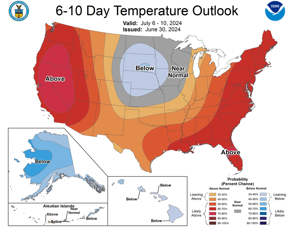
The latest 6-10 day and 8-14 day outlook from NOAA’s Climate Prediction Center favors above normal temperatures and above normal precipitation through mid-July.
The AccuWeather forecast shows highs in the mid to lower 80s through July 10, with temperatures peaking at 90 degrees this Wednesday during that span. The RealFeel temperature will be warmer, in part due to humidity, exceeding 90 degrees on Wednesday (91 degrees) and Thursday (92 degrees).
More: One dead after microburst hits popular NY campsite. What we know now
June climate stats
June saw warmer average temperatures than normal in June, with the average high of 79.5 degrees, or 1.6 degrees warmer, and the average low at 60.1 degrees, or 2.7 degrees warmer.
Total precipitation was just 0.03 inches above normal, at 3.4 inches.
All of those marks were well short of these record marks:
-
The warmest average high temperature was 85.5 degrees in 1949.
-
The warmest average low temperature was 63.6 degrees in 1919.
-
The most rain in June was 8.14 inches of precipitation in 1922.
There were several record-breaking temperature days this June, however. The warmest low temperature was set on June 18 (73 degrees) and June 19 (74 degrees) during the first heat wave of the year. The average temperature record also fell on June 19 (83 degrees).
— Steve Howe covers weather, climate and lake issues for the Democrat and Chronicle. An RIT graduate, he returned to Rochester after working around the state and in Utah. Share with him at showe@gannett.com.
This article originally appeared on Rochester Democrat and Chronicle: Fourth of July weather: Your 2024 holiday forecast in NY
Signup bonus from


