Beryl has rapidly grown to hurricane status after forming in the Atlantic late Friday. It is the first hurricane of the 2024 season and is expected to become a major hurricane by Monday.
Beryl is one of only a few storms in history that have formed over the central or eastern tropical Atlantic this early in the year, according to the National Hurricane Center.
“Only seven named storms have formed over the last 173 years in this sector of the Atlantic before July 4,” AccuWeather Chief On-Air Meteorologist Bernie Rayno said.
As of the NHC’s 5 p.m. update, the storm was 720 miles east-southeast of Barbados and moving toward the west near 22 mph. A relatively quick westward to west-northwestward motion is expected during the next few days.
On the forecast track, the center of Beryl is expected to move across the Windward Islands late Sunday night and Monday. Maximum sustained winds have increased to near 75 mph with higher gusts. Continued steady to rapid strengthening is forecast, and Beryl is expected to become a dangerous major hurricane before it reaches the Windward Islands.
Hurricane-force winds extend outward up to 10 miles from the center, and tropical-storm-force winds extend outward up to 60 miles from the center.
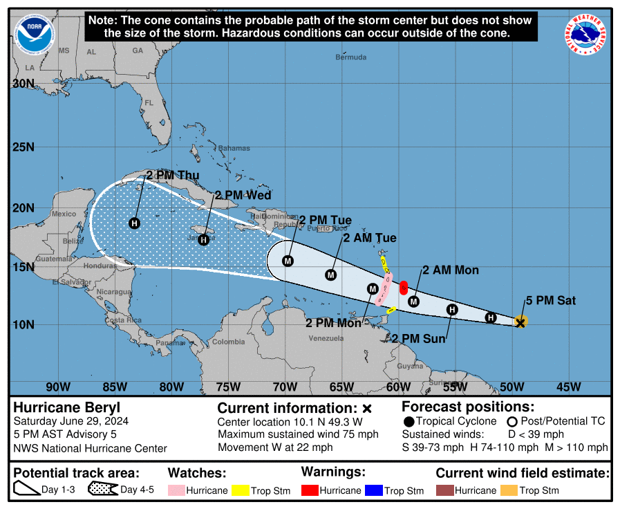
A hurricane warning is now in effect for Barbados. A Hurricane Watch is in effect for St. Lucia, St. Vincent and the Grenadine Islands, and Grenada. A tropical storm watch is in effect for Dominica, Martinique and Tobago. Additional watches and warnings will likely be required for portions of the Lesser Antilles later today.
Steering breezes will determine where the storm is pushed, therefore residents of the Caribbean, Central America and Gulf Coast are urged to monitor the system’s progress, according to AccuWeather.
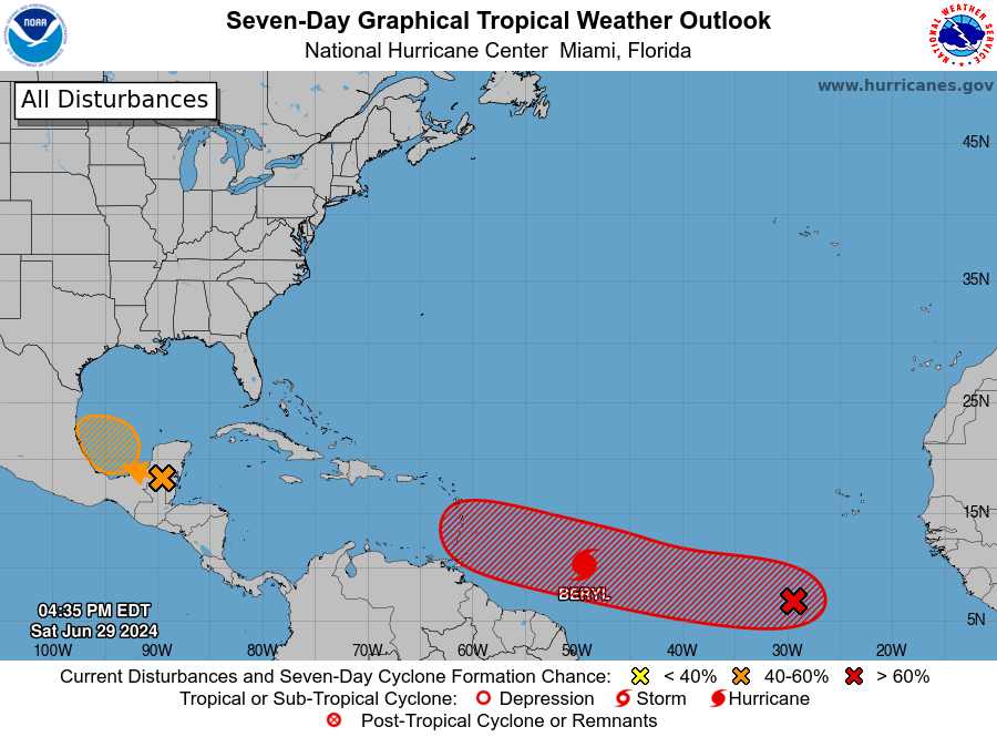
Elsewhere, Invest 94L, a low pressure system in the Southwestern Gulf of Mexico, is forecast to form over the Bay of Campeche tonight or early Sunday, where conditions appear generally conducive for further development.
A tropical depression could form before the system moves inland again early next week over Mexico. The NHC gives Invest 94L a 50% chances to develop into a named storm over the next 48 hours.
A system in the Eastern Tropical Atlantic, located several hundred miles southwest of the Cabo Verde Islands, is producing an area of disorganized showers and thunderstorms. Environmental conditions appear conducive for development, and a a tropical depression could form by the middle of next week. The NHC gives it a 30% chance of development in the next 48 hours and a 70% chance to develop over the next week.
If either of these systems develop, the next named storm will be Chris.
Hurricane Beryl: What you need to know
Watches, warnings issued across Florida
For an explanation of what the watches and warnings mean, scroll to the bottom of this story.
Hurricane warning: A hurricane warning is in effect for the following:
Hurricane watch: A hurricane watch is in effect for the following:
Tropical storm watch: A tropical storm watch is in effect for the following:
How strong is Hurricane Beryl and where is it going?
Spaghetti models for Hurricane Beryl
Special note about spaghetti models: Illustrations include an array of forecast tools and models, and not all are created equal. The hurricane center uses only the top four or five highest performing models to help make its forecasts.
Key messages from the National Hurricane Center: What you need to know about Hurricane Beryl
-
Beryl is expected to be a dangerous major hurricane when it reaches the Windward Islands late Sunday night or Monday, bringing destructive hurricane-force winds and life-threatening storm surge. Hurricane watches and warnings are in effect for much of the Windward Islands.
-
Heavy rainfall and localized flooding is expected across the Windward Islands on Sunday night and Monday.
-
Interests in the central and western Caribbean should monitor the progress of this system. Users are reminded that there is large uncertainty at days 4 and 5 and to not focus on the specific details of the track or intensity forecast.
Current forecast: Where is Hurricane Beryl going and how strong could it get?
-
12 hours: 85 mph
-
24 hours: 105 mph
-
36 hours: 115 mph
-
48 hours: 120 mph
-
60 hours: 120 mph
-
72 hours: 115 mph
-
96 hours: 105 mph
-
120 hours: 85 mph
What impact could Hurricane Beryl have and what areas could be affected?
-
WIND: Hurricane conditions are expected in the hurricane warning area beginning Sunday night. Hurricane conditions are possible in the hurricane watch areas Sunday night or Monday morning. Devastating wind damage is expected where the eyewall of Beryl moves through portions of the Windward Islands. Wind speeds atop and on the windward sides of hills and mountains are often up to 30% stronger than the near-surface winds indicated in the advisory, and some elevated locations could be even greater. Tropical storm conditions are possible in the tropical storm areas by Monday morning.
-
STORM SURGE: A life-threatening storm surge will raise water levels by as much as 5 to 7 feet above normal tide levels in areas of onshore flow near where Beryl makes landfall in the hurricane warning and watch areas. Near the coast, the surge will be accompanied by large and destructive waves.
-
RAINFALL: Tropical Storm Beryl is expected to produce rainfall totals of 3 to 6 inches across Barbados and the Windward Islands Sunday night into Monday. This rainfall may produce localized flooding in vulnerable areas. Showers and thunderstorms well north of Beryl may produce 1 to 4 inches of rain over portions of southeastern Puerto Rico on Monday night into Tuesday. Rainfall from Beryl might impact portions of southern Hispaniola on Tuesday into Wednesday with 2 to 6 inches possible.
-
SURF: Swells generated by the storm are expected to reach the Windward and southern Leeward Islands by late Sunday. These swells are likely to cause life-threatening surf and rip current conditions. Please consult products from your local weather office.
Interactive map: What tropical storms, hurricanes have impacted your area in the past?
What do the watches and warnings from NHC mean?
What is storm surge? Graphics explain the deadly weather event
Hurricane warning: A hurricane warning means that hurricane conditions are expected somewhere within the warning area. A warning is typically issued 36 hours before the anticipated first occurrence of tropical-storm-force winds, conditions that make outside preparations difficult or dangerous. Preparations to protect life and property should be rushed to completion.
Hurricane watch: A hurricane watch means that hurricane conditions are possible within the watch area. A watch is typically issued 48 hours before the anticipated first occurrence of tropical-storm-force winds, conditions that make outside preparations difficult or dangerous.
Tropical storm warning: A tropical storm warning means that tropical storm conditions are expected somewhere within the warning area within 36 hours.
Tropical storm watch: An announcement that sustained winds of 39 to 73 mph are possible within the specified area within 48 hours in association with a tropical, subtropical, or post-tropical cyclone.
Storm surge warning: A storm surge warning means there is a danger of life-threatening inundation, from rising water moving inland from the coastline, in the indicated locations. This is a life-threatening situation. Persons located within these areas should take all necessary actions to protect life and property from rising water and the potential for other dangerous conditions. Follow evacuation and other instructions from local officials.
Storm surge watch: A storm surge watch means there is a possibility of life-threatening inundation, from rising water moving inland from the coastline, in the indicated locations during the next 48 hours.
This article originally appeared on Fort Myers News-Press: Hurricane Beryl expected to become major hurricane. Forecast path
Signup bonus from