PARK TOWNSHIP, Mich. (WOOD) — A camera at Holland State Park captured a meteotsunami moving ashore as a line of severe thunderstorms struck Tuesday morning.
A meteotsunami is a type of large wave that happens when a fast-moving line of storms moves across a body of water. This was seen clearly at Holland State Park Tuesday morning, with lake water spilling onto the beach as the squall line rolled through.
Muskegon neighborhood a ‘total mess’ after storm
Unlike a typical tsunami, meteotsunamis happen when there is a significant air pressure difference. As waves crash towards the shore, they often ramp up due to an inlet or bay.
Meteotsunamis can be seen across all of the Great Lakes if the conditions are right. They are different than seiches, like the one recorded in the derecho of 1998, in which the lake sloshed back and forth, causing flooding along the West Michigan coast.
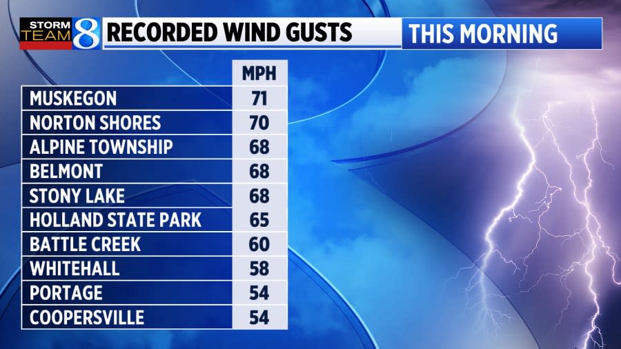
Strong winds are what pushed the waves ashore, with Holland State Park recording a gust of 65 mph along the leading edge early Tuesday.
Tuesday’s storms brought down trees and power lines around West Michigan. Muskegon County was particularly hard-hit. The damage left more than 160,000 Consumers Energy customers statewide without power, and some outages stretched into Thursday.
Copyright 2024 Nexstar Media, Inc. All rights reserved. This material may not be published, broadcast, rewritten, or redistributed.
For the latest news, weather, sports, and streaming video, head to WOODTV.com.
Signup bonus from


