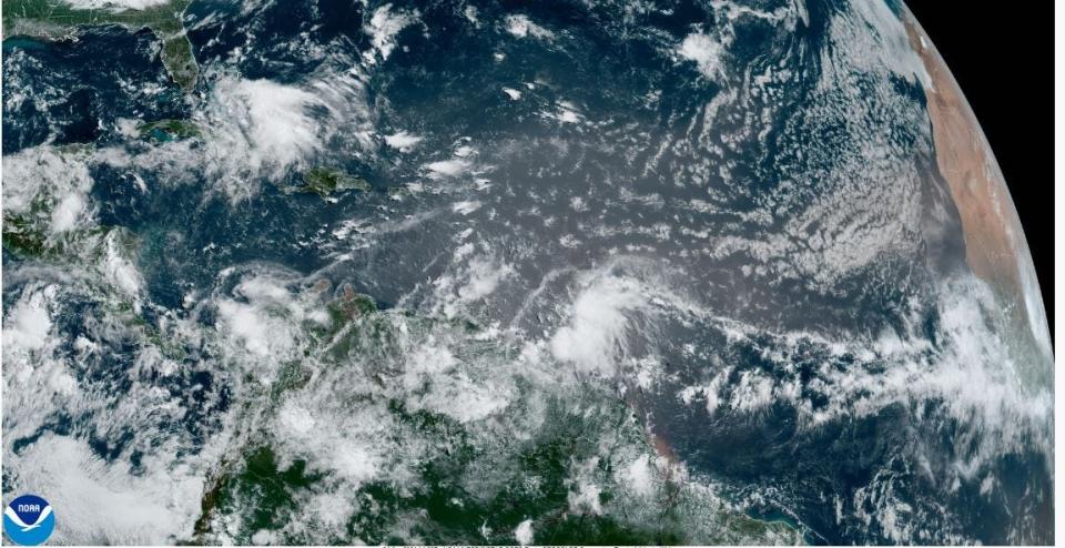
A burst of tropical vigor last week is withering in the final days of June with a Saharan dust outbreak trying to throttle storm development from Africa to the Caribbean.
The dust, made up of sand and mineral particles swept up from 3.5 million square miles of desert, could reach Florida by the weekend, said Michael Lowry, a meteorologist with South Florida ABC affiliate Channel 10, in his Eye on the Tropics blog.
Lowry said the plume is the largest since the hurricane season began June 1. It’s a common tourist in the Atlantic basin at this time of year, typically peaking in late June and early July with a proclivity to spoil tropical development by stealing moisture from the air.
“The tropical Atlantic appears ready for a summer vacation this week,” Lowry said.
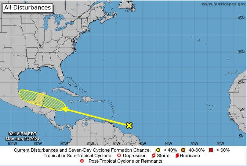
While five tropical waves were noted in the National Hurricane Center’s weather discussion on Monday, June 24, NHC meteorologists gave only one a minimal chance of tropical cyclone development over the next seven days.
For now, the unassuming knot of showers and thunderstorms is a few hundred miles east-southeast of the Windward Islands, but there could be slow development once it reaches the western Caribbean late this week, NHC forecasters said.
About 60 tropical waves leave the coast of Africa each hurricane season. One in 10, on average, develops into a depression, named storm or hurricane.
Meteorologist Ana Torres-Vazques with the National Weather Service in Miami said the Saharan dust may approach the Florida Straits by Thursday but it’s too early to say how much or where exactly it will go.
“That will evolve over time and depend on the weather pattern,” she said.
Hurricane season 2024: Rapid intensification forecasts improve, and then there was Otis

Despite forecasts for an overachieving hurricane season, the first few weeks have had just the short-lived Tropical Storm Alberto formed on June 19. Although Alberto was no more than a weak tropical storm, it pushed a dangerous flooding storm surge into Texas and killed four people in Mexico, according to the Associated Press.
Alberto formed amid a flurry of activity in the Gulf of Mexico and waters surrounding Florida that included two areas that didn’t have the oomph to make it to a tropical depression before reaching the coastline.
Through June 19, the Northern Hemisphere measured an accumulated cyclone energy, or ACE, of about 12, which is the third lowest for that time period since 1950, according to Colorado State University senior researcher Phil Klotzbach.
Accumulated cyclone energy is the measure of a storm’s longevity and vitality.
AccuWeather lead hurricane forecaster Alex DaSilva said the season so far has mimicked a typical year, although it may seem achingly slow because there have been several recent past years that came racing out of the gate. In 2023, tropical storms Arlene, Bret and Cindy formed in June. Two years earlier, in 2021, three tropical storms — Bill, Claudette, and Danny — and Hurricane Elsa formed in June.
But, on average, the first named storm of a season forms on June 20, DaSilva said. Alberto formed June 19. The second named storm doesn’t typically form until July 17, with the third trailing on Aug. 3.
“It’s not uncommon to get through most of June and July with two or three storms,” DaSilva said. “It’s basically a storm a month until mid- to late-August and September when you really start to rattle them off.”
2024 hurricane season: 5 tips to stay sane and safe in face of frightful forecast
Lowry said strong upper-level winds and Saharan dust are contributing to the lack of activity. The Central American Gyre, which spawned Alberto and Invest 93-L, which caused heavy rainfall over northeastern Mexico before dissipating, has also “retreated”, Lowry said.
“Mother Nature is taking a break for the next seven days, at least,” wrote FOX Weather hurricane specialist Bryan Norcross in a social media post made before the 2 p.m. forecast by NHC identified what could become Beryl.
Kimberly Miller is a journalist for The Palm Beach Post, part of the USA Today Network of Florida. She covers real estate and how growth affects South Florida’s environment. Subscribe to The Dirt for a weekly real estate roundup. If you have news tips, please send them to kmiller@pbpost.com. Help support our local journalism: Subscribe today.
This article originally appeared on Palm Beach Post: Saharan dust tamping down Florida hurricane activity but it won’t last
Signup bonus from