Jun. 16—RIO PUERCO VALLEY — David Ryan is driving his 2013 blue Ford Escape from Bernalillo northwest along U.S. 550 early on a recent weekday morning.
He’s got one-half of the back seat dropped down to support a dog bed, on which his rat terrier Sparky and rat terrier/Chihuahua mix Sami are reclining.
“It’s right about here where everything starts getting cool,” Ryan says.
He’s talking to a companion sitting in the shotgun seat, not the dogs. Sparky and Sami have made this trip with him enough to know the score.
“Right about here” is the convergence of the Rio Grande Rift, the southern Rocky Mountains and the Colorado Plateau. Or, put another way, about mile marker 21 on the highway.
“That’s White Mesa, where the gypsum mine is. This is all the Tierra Amarilla Anticline area,” Ryan said.
The anticline is a spectacular geological feature caused by a huge chunk of land being shoved up, so that it forms a rugged, rock wall painted in varying hues of red and brown.
“Geologists from all over the world will come out here to study this anticline,” he said. “The White Ridge Bike Trails are on the anticline. They’re good for hiking, too.”
To get into the heart of the anticline, to the bike trails or the Ojito Wilderness, you turn west off U.S. 550 just north of mile marker 21.
But that’s not where Ryan is going. He is headed farther north to the Rio Puerco Valley, which is believed to be home to the largest collection of volcanic necks in the world.
“That area could easily qualify to be a national park because the scenery is amazing,” he said.
Big head, hard hatRyan, 76, a Chicago transplant who has lived in New Mexico for more than 25 years, is the author of the recently published “Wandering in the Clear Light of New Mexico,” a guide to Gold Star, Silver Star and Bronze Star locations in every part of the state, places that Ryan knows from personal experience are worth exploring.
The Tierra Amarilla Anticline is a Gold Star location, but so are the Rio Puerco volcanic necks, this day’s destination, along with the Silver Star-rated Guadalupe Outlier.
Eighteen miles past the Village of San Ysidro, just north of mile marker 41, Ryan turned west off U.S. 550 onto the road to San Luis. This is County Road 279, even though there’s no marker identifying it as such.
“All of this area is part of the Mount Taylor Volcanic Field,” he said. Ryan said the field was active on and off from 4 million years ago to 1.5 million years ago.
“That puts it all in perspective. We are here for such a short time, so why get agitated by every little thing. There are close to 50 of these volcanic necks, or plugs, or diatremes here.”
Necks are what’s left of a volcano after the cinder cone and other materials have eroded away. The biggest one here is Cabezon (Spanish for big head) Peak, which towers 2,020 feet above the Rio Puerco. You can climb to the top of Cabezon, but it’s not easy or all that safe. Ryan recommends wearing a hard hat if you attempt it.
He drove west through San Luis, the only active settlement of four in the area, the others being Guadalupe, Cabezon and Casa Salazar. After 8.5 miles, the pavement ends.
“If it were raining or snowing, you wouldn’t want to get on the dirt road,” Ryan said. “As long as it’s dry, it’s fine. In the middle of July, during the monsoons, this road would be really difficult. When it’s wet, just don’t get on it. And never drive it at night.”
OtherworldlyAbout four miles along the dirt road, it forks. County Road 279 goes right, Bureau of Land Management Road 1114 left. Ryan turned left toward Cabezon Peak and the trailhead for hikers willing to take on its challenges. But he bypassed that and the old community of Cabezon, now on private property, and headed to Shark Tooth Ridge, so named because shark teeth fossils have been found in the area.
Slightly more than a mile past the Cabezon Peak turnoff, Ryan steered left on another fork in the road and arrived at a Shark Tooth turnoff in 2.5 miles. The vision from the ridge is mind-boggling, as if you stepped onto another planet that goes on forever, pale green valleys slashed by arroyos and fortified with imposing buttes.
“The purpose of coming out here is not to pick up shark teeth (something discouraged by nearby signs), but to enjoy the beautiful scenery,” Ryan said.
Driving back to the juncture of BLM 1114 and CR 279, you’ll see Cerro Santa Clara and Cerro de Guadalupe to the left. These impressive volcanic necks appeared on the stamp issued by the U.S. Postal Service to mark New Mexico’s 100th year of statehood.
Ryan turned west and then south on CR 279 and stopped just short of the road’s plunge into Arroyo Chico to check out spectacular views from the cliff above. Arroyo Chico and the Rio Puerco converge below.
“Look at the texture of those arroyos,” Ryan said. “There’s deep-cut arroyos all through here. That dropped the water table low and made agriculture impossible.”
Minutes later he drove through the abandoned village of Guadalupe, a collection of deteriorating adobe buildings on private land, and continued toward the Guadalupe Ruins.
Ryan believes the drive to the ruins should be counted among the best in the country.
“For scenery, I think it’s better than the drive to Big Sur on California Highway 1.” he said.
Beautiful both ways
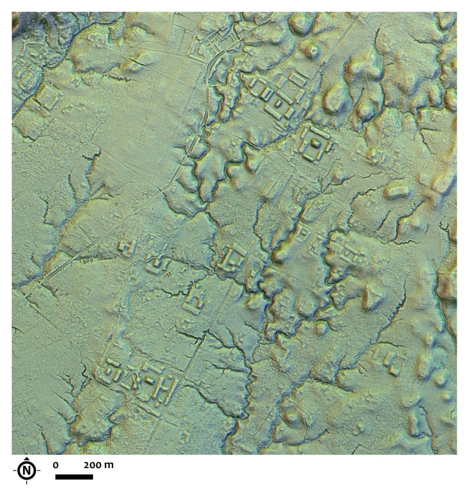
The Guadalupe Ruins, which sit atop a small but steep mesa, are 29.5 miles from U.S. 550. They are believed to be among outlying great houses built 1,000 years ago as part of the community rooted in Chaco Canyon. There is speculation that the house here was constructed to oversee the output of turquoise in the Cerillos Hills.
It’s a short trail up to the ruins, but the grade is fairly tough. If you have been to Chaco Canyon, you will no doubt notice that the ruins’ stone work is reminiscent of that that make up the houses at Chaco. But the view from this perch is so mesmerizing it might be you forget to look at ancient walls.
Back down at the base, Ryan pointed out a dike, a seam of volcanic lava cutting through the surface rock on the north side of the mesa. It is as far as you can see in either direction, making Ryan wonder just how far it goes. Maybe one day he and Sparky and Sami will find out.
Then it’s time to drive back to U.S. 550. Ryan smiled.
“The drive is just as beautiful going the other way,” he said.
Signup bonus from