A tornado watch has been issued Saturday for parts of southeastern South Dakota.
The watch, which means the atmosphere has the possibility of producing such threats, is expected to remain in place until 10 p.m., according to the National Weather Service office in Sioux Falls. A warning means the threat is happening.
A tornado watch has been issued for parts of Iowa, Kansas, Minnesota, Missouri, Nebraska and South Dakota until 10 PM CDT pic.twitter.com/eu7Ny2imGe
— NWS Sioux Falls (@NWSSiouxFalls) June 15, 2024
The NWS Storm Prediction Center includes these counties as part of the watch:
-
Clay
-
Lincoln
-
Turner
-
Union
-
Yankton
The watch also extends into parts of Iowa, Kansas, Minnesota, Missouri and Nebraska.
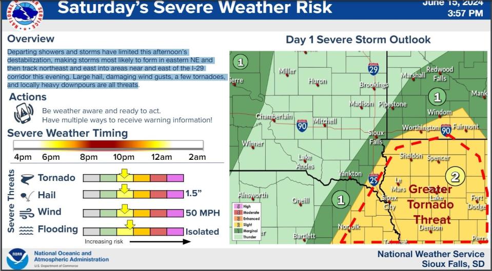
“Departing showers and storms have limited this afternoon’s destabilization, making storms most likely to form in eastern NE and then track northeast and east into areas near and east of the I-29 corridor this evening,” the NWS stated in its latest weather briefing online. “Large hail, damaging wind gusts, a few tornadoes, and locally heavy downpours are all threats.”
The highest chance for severe weather is anticipated between 8 and 10 p.m. for South Dakota, the NWS states.
Severe storm chances are then possible again between 10 p.m. and 4 a.m. Sunday night into Monday for the area, with heavy rain, hail and damaging winds possible, according to the NWS.
“We’ll continue to see shower and storm chances through the middle of next week,” the NWS states in its forecast online. “Some storms could be strong to severe so remain weather aware and have a plan should a warning be issued in your area. Heat and humidity increase with heat indices climbing near to above 100 degrees. Breezy winds prevail.”
Follow and refresh this page for the latest information.
This article originally appeared on Sioux Falls Argus Leader: Lincoln County under tornado watch Saturday night
Signup bonus from
