Florida is dealing with another day of rain and devastating flash flooding despite already reeling from historic rainfall that has left entire neighborhoods underwater.
Six million people remain under a flood watch through Friday evening across southern Florida, including metro areas of Miami, Fort Lauderdale, West Palm Beach, Fort Myers and Naples.
Thus far, scattered showers and storms hit southern Florida Friday afternoon, but not as widespread or persistent as the last few days.
Over 20 inches of rain has fallen in south Florida since Tuesday and an additional two to four inches will be possible through early Saturday.
There’s a moderate risk for flash flooding across the areas under the flood watch as well, marking the fourth straight day of flood concerns for South Florida.
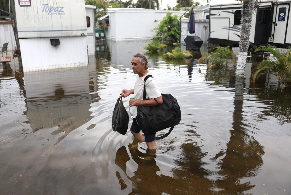
The Miami to Fort Lauderdale corridor remain highly vulnerable to flash flooding — it could take only 0.25 inches of rain in just one hour to spark new flooding as the ground is still heavily saturated with little time for water to recede.
Respite, however, is around the corner with rain forecast to subside Saturday through the weekend.
Over 2 feet of rainfall was recorded over the past 72 hours at Miami-Dade College – North Campus. Over 20 inches of rain was clocked at Miami-Dade College – Hialeah Campus, over 19 inches in the Everglades, over 18 inches at the University of Miami and 13.51 inches at Miami Beach.
South Florida has been drenched in a deluge that started Tuesday into Wednesday, with a brief break on Thursday before more rain pounded down. This week’s downpour forced flight cancellations at airports, residents to abandon cars in high water and the rescue of locals from flooded vehicles and homes.
For some longtime residents, no strangers to severe weather, the intense flooding has been alarmingly extreme.
“This has been the worst in like 20 years. We’ve been here for 20 years and we’ve never seen this, even through a hurricane.” Steven Bunchan, a North Miami resident, told NBC News.
As of 8 a.m. Friday, a few scattered showers are coming down in South Florida.
“There is still standing water in several neighborhoods in southeastern Broward/northeastern Miami-Dade counties. Please exercise caution if you encounter any residual flooding,” the National Weather Service office in Miami warned.
Continued heavy to excessive rainfall may bring considerable to locally catastrophic urban flooding through Friday across South Florida. Elsewhere across Florida, flash and urban flooding remains possible through Saturday. A slight risk of severe thunderstorms (Level 2 of 5)… pic.twitter.com/66SB6kGUdD
— National Weather Service (@NWS) June 14, 2024
Elsewhere in the U.S., 31 million people are under the risk for severe storms Friday across two areas: one across the western high Plains and the other in the Northeast.
In the Northeast, a slight risk extends from just west of New York City down to west of Washington, D.C. Boston is the biggest city in the risk zone and the areas of Hartford, Connecticut; Poughkeepsie, New York; and Allentown, Pennsylvania; are most likely to see rounds of strong winds and hail.
Across the western high Plains, strong wind gusts of 75 mph and over are the greatest threat, followed by large hail and isolated tornadoes with Denver and Colorado Springs, Colorado; and North Platte, Nebraska, being the largest cities at risk.
Heat that has been baking the Southwest will spread to the Midwest and Northeast into next week.
This weekend 12 million people are under heat alerts across the West and into Southwest Texas with triple-digit highs forecast including a high of 113 in Phoenix forecast Saturday.
Highs in the 90s are forecast for the Southeast, where high humidity will make it feel like over 100 degrees.
This article was originally published on NBCNews.com
Signup bonus from