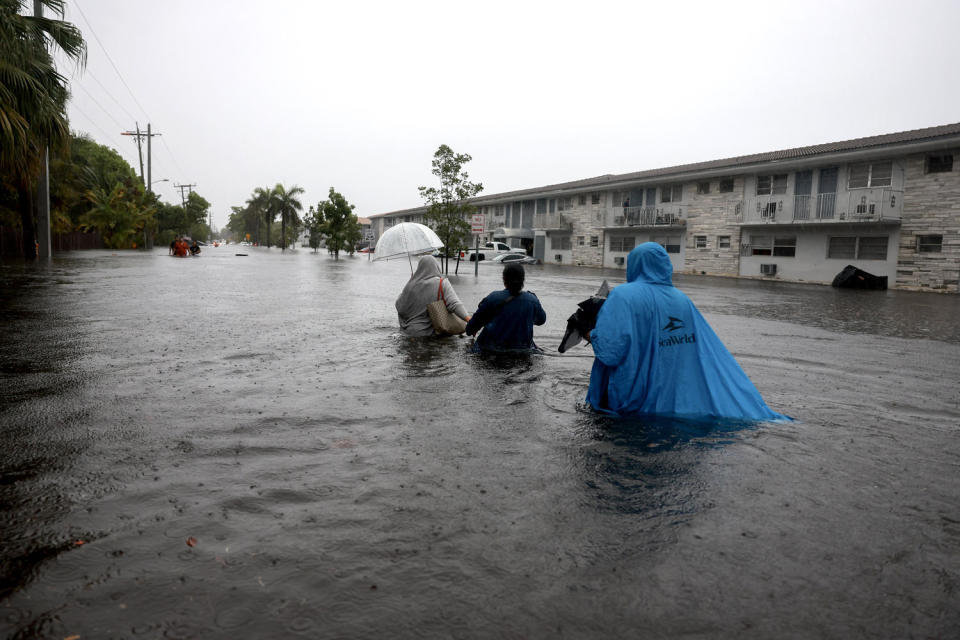
A slow-moving storm system infused with deep tropical moisture over South Florida will bring more very heavy rain and thunderstorms Thursday — one day after flash flooding turned streets into rivers and triggered hundreds of flight delays and cancellations. Over a foot of rainfall was clocked in multiple areas.
Seven million people remained under a flood watch Thursday across South Florida for what’s forecast to be a third day of intense deluge.
“Even a small duration of heavy rainfall could lead to more flash flooding!” the National Weather Service office in Miami warned on X.
🧵: Today’s Forecast Concerns!
An additional round of heavy rainfall is forecast across SFL today as a large convective band of showers & thunderstorms develops & move southward for the 3rd day in a row. Even a small duration of heavy rainfall could lead to more flash flooding! pic.twitter.com/n2MSwzkp3F
— NWS Miami (@NWSMiami) June 13, 2024
As of Thursday morning, flood warnings were allowed to expire in parts of southern Florida, but residual flooding continues and several roads remain closed in hard hit areas. Heavy rain is forecast to pick up in the afternoon and evening hours
The National Weather Service’s Weather Prediction Center has issued a moderate risk of excessive rainfall through Friday morning.
The heavy rain will create “numerous areas of flash flooding,” the weather service said. “Furthermore, many streams may flood, potentially affecting larger rivers.”
The Miami metro area has practically zero tolerance for any more rain. Flash flood guidance reveals it’ll take less than 0.25 inches of rain in just one hour to cause parts of the metro area to flood instantly.
Wednesday’s downpour saw Gov. Ron DeSantis declare an emergency in Broward, Collier, Lee, Miami-Dade and Sarasota counties, allowing for state aid. The cities of Miami, Fort Lauderdale and Hollywood also issued emergency declarations.
Cars got stuck on inundated roads, water filled homes, locals were urged to stay in their residences, local airports saw hundreds of delays and cancellations, and part of the Interstate 95 in Broward County was closed to traffic for water to be drained.
The city of Aventura’s police said that over 300 vehicles were towed off roadways and elderly individuals were rescued Wednesday from trapped vehicles.
Fort Lauderdale picked up 9.54 inches of rain in 24 hours, with Wednesday marking their wettest June day on record, and the third wettest calendar day on record.
Overall, at least six weather stations from Miami to Fort Lauderdale picked up over 10 inches of rain — the highest being 13.96 inches over Hialeah and 12.67 inches over the Hollywood/Hallandale Beach area. Most of the 10 to 12 inch rain totals came over the span of just five to six hours Wednesday.
When combining Tuesday’s rainfall, some locations across South Florida have picked up more than 20 inches of rain in just two days.
The more than a foot of rainfall that came down in just six hours over the Everglades reached the criteria for a 1-in-1,000-year event — the second in just two days.
On Friday, the threat of excessive rainfall will decrease slightly over the southern tip of Florida, and a slight risk of excessive rainfall is in place for South Florida from Friday into Saturday morning.
Through Saturday morning, an additional 5 to 10 inches of rain will be possible including for the metro areas of Naples, Fort Myers, Miami, Fort Lauderdale and West Palm Beach.
This article was originally published on NBCNews.com
Signup bonus from