Although the first day of summer isn’t until next week, the season’s scorching heat and humidity have settled into Kansas City, according to the National Weather Service.
The weather will be dangerously hot on Thursday, with temperatures climbing into the mid- to upper 90s. The weather service said some areas in northeast Kansas and northwest Missouri may flirt with their first 100-degree day. High humidity will make it feel muggy and send heat index values between 100 and 106 degrees.
Dew points across the region will be in the low 70s, which means there’s a lot of moisture in the air, making the heat feel oppressive.
“SW (southwest) winds gusting around 20-25 MPH will make it feel a little more like a blast furnace than a refreshing breeze,” the weather service said in its forecast discussion.
The Kansas City area is under a heat advisory from 1 to 8 p.m. The weather service advises people to drink plenty of fluids, stay in air-conditioned rooms, and stay out of the sun. People should also check on their vulnerable relatives and neighbors.
When temperatures are this hot early in the season, the risk of heat illnesses is higher because bodies have not yet had a chance to adjust to the heat.
Giant hail possible
In addition to the oppressive heat, the Kansas City area is at risk of strong to severe thunderstorms in the evening.
Scattered thunderstorms should develop along a cold front near the Iowa and Missouri border by late afternoon. The storms will move south this evening and into the night.
“While uncertainties continue, confidence is increasing that if storms form, they will likely grow severe rather quickly, dropping large to possibly giant hail (2-4 inches), damaging winds, and heavy rainfall,” the weather service said. A couple of tornadoes could be possible.
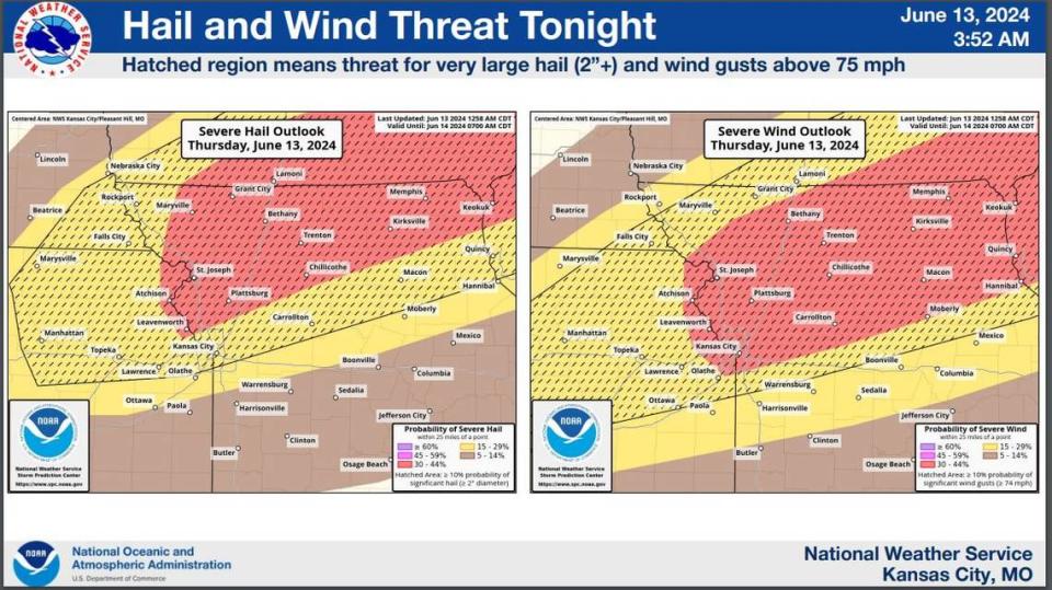
The atmosphere is extremely unstable, with a high amount of energy available for thunderstorm development. The weather service said there are some factors that could limit how widespread the storms are, so some areas may see strong to severe thunderstorms while others may see no storms at all.
The weather service’s Storm Prediction Center has placed parts of the Kansas City region, including the metro area, under an enhanced risk of thunderstorms. Kansas City is also included in an area at risk of significant severe hail that stretches from the metro across northern Missouri and southern Iowa into Illinois.

Hot, humid weather settles in
The heat and humidity will remain in the Kansas City area over the weekend and next week as summer officially begins on June 21st. Temperatures will be in the low to mid-90s. Temperatures in Kansas City for this time of year typically are in the low to mid-80s. Dew points will remain at a level where the heat feels oppressive.
Showers and thunderstorms will likely return Friday night into Saturday. The environment, however, looks tumultuous, the weather service said. However, isolated strong to severe storms cannot be ruled out.
Intermittent storm chances return Saturday afternoon and persist overnight into Sunday morning.
“Somewhat fitting as the summer solstice approaches, the summertime weather pattern of hot, humid air combined with multiple rounds of showers and thunderstorms settles in,” the weather service said.
A live data feed from the National Weather Service containing official weather warnings, watches, and advisory statements. Tap warning areas for more details. Sources: NOAA, National Weather Service, NOAA GeoPlatform and Esri.
Signup bonus from