A messy area of showers and thunderstorms in the eastern Gulf of Mexico was highlighted early Tuesday by the National Hurricane Center as having a 20% chance of development over the next seven days.
The trough of low pressure is expected to move northeastward across Florida during the next few days with the best chances of spinning up into a tropical system after it passes over the state and enters the Atlantic Ocean off the southeast coast later this week.
If a tropical cyclone forms, it would be the first named storm of the season, bearing the moniker Alberto.
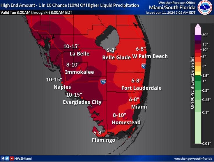
Regardless of what becomes of the sloppy blob, heavy rainfall is expected throughout South Florida through at least Friday with the National Weather Service forecasting as much as eight inches of rain through Thursday night in Palm Beach County and up to a foot of rain along the southwest coast.

Flood watch in effect for all of South Florida
A flood watch, which is in effect for all of South Florida through Wednesday night, may be extended if the ground becomes saturated leaving it more prone to flooding.
Chris Fisher, a meteorologist with NWS Miami, said a stalled front across the northern reaches of the state will be the catalyst for much of the rainfall, helping pull up moisture from the Caribbean.
Hurricane season 2024: What to do with your boat in Florida if a storm approaches
“The key thing to remember is the rainfall amounts will be highly variable so there are certainly areas that can see more and some that will see less,” Fisher said. “There are flooding concerns across metro areas, especially if you get repeated rounds of heavy rain over the same area.”
What Colorado State University says about the hurricane seasonal forecast
Colorado State University is scheduled to release its updated 2024 seasonal hurricane forecast on Tuesday, June 11 at 11 a.m.
With no early season storms so far on the map, it may not change much from the previous forecast in April, which included 23 named storms. Of those, 11 are forecast to become hurricanes with five becoming major hurricanes.
The average hurricane season has 14 named storms, including seven hurricanes. Of the seven hurricanes, three become major hurricanes.
But the most immediate worry is the rainfall.
“We are concerned about a ‘wall of rain’ inundating Florida this week,” said AccuWeather lead long-range forecaster Paul Pastelok. “While we can’t rule out an organized tropical depression or storm, the impact will be similar due to the rounds of tropical downpours.”
Kimberly Miller is a journalist for The Palm Beach Post, part of the USA Today Network of Florida. She covers real estate and how growth affects South Florida’s environment. Subscribe to The Dirt for a weekly real estate roundup. If you have news tips, please send them to kmiller@pbpost.com. Help support our local journalism, subscribe today.
This article originally appeared on Palm Beach Post: Hurricane Center watching system in Gulf of Mexico could be Alberto
Signup bonus from


