Anyone who has lived in Volusia or Flagler counties for the past couple of years probably feels anything but lucky when it comes to getting hit by storms.
But Hurricane Ian and Hurricane Nicole ― which caused hundreds of millions in estimated damage to the two coastal counties combined ― weren’t major hurricanes by the time they got here. Both transitioned from Category 1 status to tropical storms as they moved through the area. And that was bad enough.
In fact, the area has been relatively fortunate when it comes to getting hit by big storms.
Daytona Beach, for example, has not gotten a direct hit from a Category 4 or 5 storm in recorded history, which dates back to 1850, says Will Ulrich, warning coordination meteorologist with the National Weather Service in Melbourne.
But that doesn’t mean it will never happen. And even lesser storms can cause massive damage as the community learned from Ian and Nicole.
Add to that, the outlook for hurricanes this year is more dire than normal. Colorado State University predicted 23 named storms,11 hurricanes, and five hurricanes at a Category 3 level or above.
So what do residents do if a superstorm is headed this way? Experts say run. Run fast and run early.
Donna, Charley and more: What Volusia has seen before
Make no mistake, Volusia County has seen its share of heavy weather. The National Oceanic and Atmospheric Administration’s Historical Hurricane Tracks tool shows that several big storms have churned through Volusia County but none above a Category 2. That level of storm brings maximum sustained winds of 110 mph.
The site lists 41 storms, some at tropical storm strength or below when they got here, that directly crossed over some parts of Volusia County. Others, such as Ian and Nicole, still impacted the area even though their centers didn’t pass over the county.
In 1921 an unnamed storm sliced from west to east across about the southern half of the county.
The hardest hits on record include an unnamed storm in 1926, which cut into the county around Ponce Inlet as a Category 2 and then became a Category 1 as it moved northwest.
Some may remember Hurricane Donna in 1960, the center of which moved diagonally through the county from southwest to the northeast as a Category 1 hurricane. Charley did the same in 2004.
And in 1979 Hurricane David skirted the southeastern part of Volusia as a Category 2 storm.
Some of the most damaging storms didn’t hit the county directly.
A close call came in 2016 when Hurricane Matthew’s center stayed just offshore as it moved north past Volusia County as a category 3 storm. But it still caused damage, including destroying over 40 county beach walkovers, according to a Volusia County government presentation.
Why no direct hits?
Ulrich said the concave shape of the coastline from about Cape Canaveral to Southeast Georgia has played a role in sparing the area so far.
Storms coming from the Atlantic are typically moving in a north or northwest trajectory when they get close to this area, and the shape of the coastline “aligns nicely” with that.
“It allows most storms to parallel the East Central Florida coastline vs. taking a direct hit,” he said.
Hurricane Matthew is an example of that traditional movement. It was a Category 3 storm but remained offshore of Volusia County.
“And so we came within about 40-50 miles of potentially serious impacts,” Ulrich said.
The area has been spared so far. But while a superstorm isn’t likely, every hurricane season brings a new possibility of the worst-case scenario.
Major hurricane strike would be devastating
So back to Ian and Nicole for a moment. Let’s say those storms were Category 1 the entire time they passed rather than tropical storms with maximum sustained winds of 39-73 mph. What if they were Category 4s?
A Category 4 hurricane has around 250 times the damage potential of a Category 1, Ulrich said. In other words, things would have been much, much worse.
A Category 4 storm with sustained winds of 130-156 mph can cause severe damage to even well-built homes, tear up roofs and walls, snap or uproot most trees and take down power poles, according to the National Hurricane Center.
A category 5 storm with sustained winds of 157 mph or higher will destroy “a high percentage of framed homes” with roofs failing and walls collapsing.
During the storm, people who don’t evacuate might not be able to reach 911 or get any kind of emergency help.
Daytona Beach and beyond could be uninhabitable and without power for weeks or months in a Category 4 or 5 storm.
“There’s this potential for such huge impacts on things that we normally take for granted every day that it’s really hard to fathom,” Volusia County Emergency Management Director Clint Mecham said.
Imagining the worst: A major hurricane hits Volusia County
Let’s say a major hurricane is, in fact, making its way toward the area from the Atlantic.
A week out and the area is in the cone of uncertainty. Grocery store shelves are emptied, lines are forming at gas stations and calls pour into the Emergency Operations Center as people realize they’re going to have to get out of town. Some folks have medical issues or other special needs. Others have no home at all. And what about pets?
Emergency officials are under tremendous pressure, mulling when to start calling for mandatory evacuations.
Problem No. 1 is the bridges. There are eight bridges that connect the coastal areas to the mainland.
Sustained winds of 39 mph is one element officials consider when looking at closing bridge traffic, Mecham said. Bridge approaches could also be underwater.
And it’s not just about getting people to the mainland.
“We’ve got to look at not only the chokepoints but all of the surface streets and the infrastructure that funnels into those chokepoints,” Mecham said.
Information from the 2020 Census shows that more than 250,000 people in Volusia County fall within one of five zones that could be called on to evacuate, according to county spokesman Clayton Jackson.
Just how long will it take to get everyone out of here? And what happens to those stubborn few who stay behind?
What if a hurricane hits Daytona Beach?
No one can say for certain what happens if a major hurricane like an Andrew or an Ian hits the bullseye such as the Daytona Beach Pier. Every storm is different; every shoreline has its own characteristics.
But it’s possible to get a pretty good idea.
In addition to wind damage, the storm surge would be devastating.
Ulrich used hurricane model technology to estimate storm surge flooding. Rain and wave action aren’t a part of that.
A Category 4 storm hitting Daytona Beach coming from the east-southeast and moving 15 mph could produce up to 7-10 feet of surge flooding along parts of the Halifax River and coastline, Ulrich said.
“The highest values would occur in areas that are more flood-prone ― areas along the immediate waterfront, closer to sea level, or low-lying along the river,” Ulrich wrote in an email to the News-Journal. “Values would lower as you move away from the shoreline and coast (as elevation increases).”
He also looked at a couple of worst-of-the-worst-case scenarios, where the model gives “estimated peak values of storm surge for each storm strength.” It “takes into account all possible scenarios for each type of storm” and gives a possible maximum range in severity. But a storm of the same strength with some factors changed could produce less flooding.
A Category 4 hitting Daytona Beach could produce up to 4-7 feet of flooding at the State Road A1A and International Speedway Boulevard intersection, which is where the “World’s Most Famous Beach” sign is. A Category 5 storm at that same intersection could bring up to 8-10 feet of flooding.
Karen Clark is co-founder and CEO of Boston-based firm Karen Clark and Company, a business that conducts catastrophe modeling for insurance companies and other entities.
She provided wind and storm surge estimates for Volusia and Flagler counties and beyond for a Category 4 hurricane with peak winds of 155 mph hitting near Daytona Beach.
In that scenario, winds of 100 mph or greater would extend across most or all of both Volusia and Flagler counties and beyond.
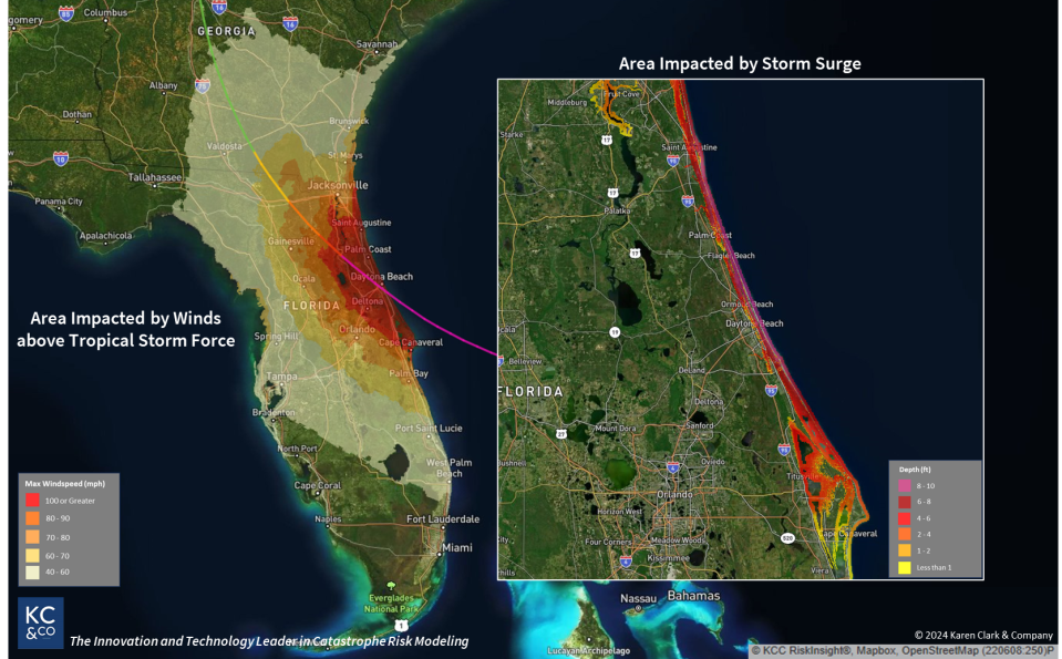
Much of the immediate coastline in Volusia and Flagler counties is estimated to see storm surge flooding of 8-10 feet, including near the boardwalk and pier in Daytona Beach. The Halifax River would swell and flood surrounding areas.
Midtown, an area notoriously vulnerable to flooding, would see storm surge flooding of several feet in pockets.
U.S. 1 could also face severe flooding, including in Ormond Beach and Port Orange. Some parts of Ormond Beach and Ponce Inlet could see storm surge flooding of up to 10 feet.
The surge could bloat the Tomoka River even to the west of Interstate 95 and near the State Road 40 interchange, bringing several feet of storm surge.
Water weighs about 1,700 pounds per cubic yard. Along the coast, the surge can combine with pounding waves to wreak havoc.
“We tell people, ‘Run from the water; hide from the wind,” Ulrich said.
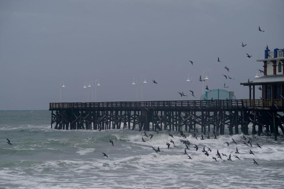
Daytona boardwalk could be washed out
Mark Luther is deeply familiar with the power of water. He is an associate professor at the University of South Florida and is the university’s director of the Center for Maritime and Port Studies.
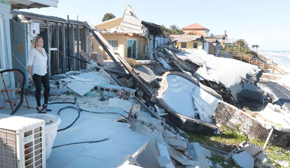
Water will knock anything down in its path, especially if there are pounding waves following it. And even if the water isn’t moving fast enough to knock down walls, it’s still probably going to get inside buildings.
“You could expect significant beach erosion,” he said. “They’re probably going to wash out the boardwalk and perhaps even the streets closest to the beach, and perhaps undermine many of the homes and other structures.”
Most condos have deeply anchored pilings that help keep them standing. Whether buildings would remain depends on how they’re built.
A storm surge risk map tool from the National Hurricane Center shows flooding on bridge approaches in Volusia County that connect to the coastal areas underwater in a Category 4 or 5 storm.
So even people in newer buildings that are built to current flood standards should evacuate when ordered and in plenty of time.
“The roads are already going to be underwater before the storm gets here, so get out while the getting’s good,” Luther said.
A $53 billion punch
Clark says the chances of a direct hit aren’t likely.
“To actually have a landfall exactly at Daytona Beach is a lower probability … would be much lower than 1 in 100,” Clark said.
Areas farther south such as Miami-Dade County are at higher risk of seeing a direct landfall than more northern areas of the state.
“But it doesn’t mean that you could not sustain a direct hit, which you can,” she said.
Such a storm could bring about $53 billion in insured losses for wind and storm surge damage, Clark said. Daytona Beach would be one piece of that.
The East Coast of Florida is less susceptible to storm surges than Florida’s West Coast because of the bathymetry and orientation of the coastline, she said.
“You don’t have … major bays like you do around Tampa and Fort Myers,” she said.
Hurricane preparedness: Be ready, be watchful
Mecham and his team at Volusia County Emergency Management have been sharing presentations around the county to help get residents ready.
Besides the obvious things like having an evacuation plan and hurricane supplies, people should also think ahead about flood insurance.
“Many policies take upwards of 30 days after purchase to take effect,” according to the Florida Division of Emergency Management.
Details on hurricane preparedness are available through Emergency Management at volusia.org/services/emergency-services.
Luther said that details of the impacts of any storm are “almost unknowable” over 12 hours before a storm hits because they can change in direction or some other way at the last minute.
“They’ll become much, much stronger than predicted at the last minute, especially off of Daytona because the Gulf Stream is right there. … When storms hit that big pool of warm water, they intensify very rapidly quite often,” Luther said.
Luther said people should have an evacuation plan and pay close attention to forecasts because things can change at the last minute.
“I can flip a coin 100 times and it will come up heads 100 times, but every time I flip it there’s still a 50-50 chance it’s going to come up tails,” he said. “And it’s just the same with the storm surge and hurricane probabilities, that just because it hasn’t happened in a long time doesn’t mean you’re due for it to happen. But it also doesn’t mean that it’s not going to happen.”
This article originally appeared on The Daytona Beach News-Journal: Imagining worst-case hurricane scenario in Volusia County, Florida
Signup bonus from