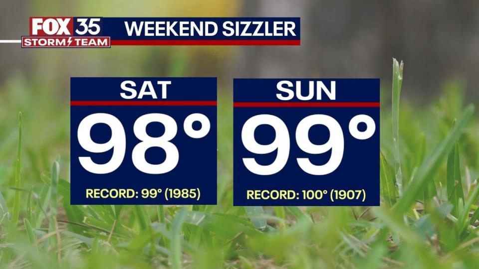
SUNDAY: It will be a mild start to Sunday with potential for some inland patchy fog. Into the afternoon, we’re in for another scorcher of a day with highs surging into the mid to upper 90s across Central Florida. Near-record heat will be likely with heat index values that could reach 105-108. At those levels it is dangerous to be outside for extended periods of time. Keep cool! In terms of our rain chances, dry air still remains which will keep any shower or storm chance isolated at best. Better rain chances await next week.
Records Sunday:
-
Orlando – 100° (1907)
-
Sanford – 98° (2006)

We will continue to see dangerous heat on Monday with highs back into the upper 90s. Some relief could appear by the afternoon with scattered storm chances.
LOOKING AHEAD: A major pattern change is on the way for the new work week. This change will help bring some much needed rain to Central Florida and hopefully help reduce and lessen drought conditions throughout the state. A low pressure system looks likely to bring a surge of tropical moisture into the Gulf of Mexico and spread to Florida. This would allow for daily chances of storms. Tropical downpours will be likely each day with increased potential for some flooding by the end of the week. There remains a decent spread in rain totals, but for now a range of 1-5″ seems fair for our area with localized higher values.

IN THE TROPICS: The messy low pressure system in the Gulf next week is unlikely to become anything. Models show a limited potential for a weak tropical depression. Any impact would likely be rain and some wind. Elsewhere in the tropics, it remains quiet.
Signup bonus from