Temperatures across portions of Florida could hit record highs over the weekend before tropical moisture arrives next week.
AccuWeather forecasters are predicting temperatures could be 5 to 10 degrees above historical averages Friday through Sunday.
➤ Tropics watch: Get the latest on what’s happening in the tropics
The potential for record heat means an increased risk for heat-related illnesses, including heat exhaustion and heat stroke.
Here’s what you should know.
Florida residents facing record heat
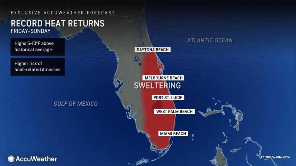
Temperatures are expected to climb to 5 to 10 degrees above historical averages, according to AccuWeather. That means highs well into the 90s for much of Central and South Florida.
Add the heat index on top of that and you have “feel like” temperatures well into triple digits.
By Friday, high temperatures are expected to get into 90s with portions of interior Central Florida approaching the upper 90s, according to the Florida Division of Emergency Management.
“Muggy conditions will create triple digit heat index values statewide on Friday afternoon, which may allow for heat advisories across portions of Southeast Florida. Slightly cooler conditions will return along the western Panhandle in the wake of the cold front, while temperatures across the rest of the state will reach the middle 90s, and upper 90s across Central Florida.
“Heat index values throughout the Peninsula will remain in the upper 90s and triple digits — 100-105 — on Saturday, with possible heat index values within heat advisory criteria across Southeast Florida.”
What is a heat advisory?
A heat advisory is one of several types of health alerts issued by the National Weather Service. A heat advisory is issued within 12 hours of the onset of extremely dangerous heat conditions. The general rule of thumb for this advisory is when the maximum heat index temperature is expected to be 100 degrees or higher for at least two days, and nighttime air temperatures will not drop below 75 degrees. These criteria vary across the country, especially for areas that are not used to dangerous heat conditions.
In Florida, except for Miami-Dade County, the National Weather Services offices around the state would issue a health advisory if the heat index is expected to reach 108 to 112 degrees. The National Weather Service Miami said Miami/Dade County wanted a lower threshold for an advisory for its population, which was set at 105 degrees.
If a heat advisory is issued, take precautions to avoid heat illness. If you don’t take precautions, you may become seriously ill or even die.
Tropical moisture next week could alleviate Florida drought conditions
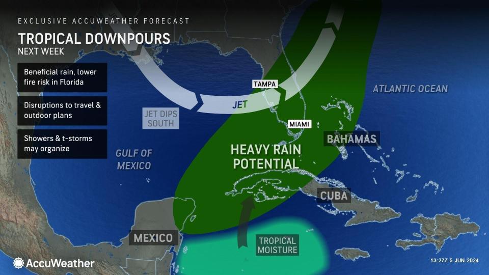
A dip in the jet stream could bring some tropical moisture into Florida next week, AccuWeather said.
“This could provide just enough extra spin and moisture to get something going in the zone from the northwestern Caribbean and the eastern Gulf of Mexico to waters east of Florida toward the middle of next week,” said AccuWeather Chief On-Air Meteorologist Bernie Rayno.
If the dip leaves quickly, the disturbance may get left behind and could enter the central Gulf of Mexico, where it would have an opportunity to strengthen late next week and be more of a concern for the central Gulf Coast.
While there’s a low chance of tropical development now, “there is the potential for several inches of rain to fall on part of the Sunshine State,” AccuWeather said.
“At this time, the most likely area for heavy rainfall will be the southern and central counties of the Florida Peninsula. However, there is a chance the moisture surge occurs farther to the north in the Gulf, which might mean more rain farther to the north in Florida.”
Weather alerts issued in Florida

A dry cool front is forecast to move into the area Friday night, bringing drier air, but expect temperatures to rise above seasonal averages Saturday — with temperatures around 90 — before low temperatures drop to the upper 60s, according to the National Weather Service Mobile.
-
Thursday: Showers and thunderstorms, mainly after 7 a.m. High near 84. Southwest wind 10 to 15 mph, with gusts as high as 20 mph. Chance of precipitation is 80%. New rainfall amounts between a quarter and half of an inch possible.
-
Friday: A 20 percent chance of showers and thunderstorms after 1 p.m. Sunny, with a high near 89. Northwest wind 5 to 10 mph becoming west in the afternoon.
-
Saturday: Sunny, with a high near 88. North wind around 5 mph becoming south in the afternoon.
-
Sunday: Sunny, with a high near 89. Northwest wind 5 to 10 mph becoming southwest in the afternoon.
Follow National Weather Service Mobile on X, formerly known as Twitter
With dry conditions the heat will remain widespread, with temperatures in the mid to upper 90s expected on Sunday. Rain chances increase Monday and Tuesday as a weak frontal boundary drops in from the north and stalls. There’s a possibility of increasing tropical moisture arriving from the south starting Wednesday, according to the National Weather Service Tallahassee.
-
Thursday: Showers and thunderstorms likely, mainly after 4 p.m. Mostly sunny, with a high near 92. Heat index values as high as 102. Light southwest wind increasing to 5 to 10 mph in the morning. Chance of precipitation is 60%. New rainfall amounts between a quarter and half of an inch possible.
-
Friday: A 40 percent chance of showers and thunderstorms. Sunny, with a high near 94. Heat index values as high as 102. West wind around 5 mph.
-
Saturday: Sunny, with a high near 94. North wind around 5 mph.
-
Sunday: Sunny and hot, with a high near 96.
Follow the National Weather Service Tallahassee on X, formerly known as Twitter
There’s a chance for some morning showers and thunderstorms Friday, increasing in the afternoon in Northeast Florida. Daytime temperatures will be in the low to mid 90s. Conditions should dry out by Saturday as a cold front moves south through the region. Monday starts the beginning of what looks to be another rainy week with another cold front making its way in by Monday morning, according to the National Weather Service Jacksonville.
-
Thursday: A chance of showers and thunderstorms between 3 p.m. and 5 p.m., then showers likely and possibly a thunderstorm after 5 p.m. Increasing clouds and hot, with a high near 97. Heat index values as high as 104. Light southwest wind increasing to 6 to 11 mph in the morning. Winds could gust as high as 17 mph. Chance of precipitation is 60%. New rainfall amounts between a tenth and quarter of an inch, except higher amounts possible in thunderstorms.
-
Friday: A chance of rain before 11 a.m., then a chance of showers and thunderstorms after 11 a.m. Mostly sunny and hot, with a high near 95. Heat index values as high as 102. West wind 9 to 11 mph, with gusts as high as 17 mph. Chance of precipitation is 40%.
-
Saturday: Sunny and hot, with a high near 95. Northwest wind around 8 mph becoming north in the afternoon.
-
Sunday: Sunny and hot, with a high near 98.
Follow the National Weather Service Jacksonville on X, formerly known as Twitter
Scattered to numerous showers and lightning storms will develop toward mid to late afternoon and through Thursday evening. Strong to isolated severe storms will be possible, with the main threats including frequent lightning strikes, strong to locally damaging wind gusts around 40 to 60 mph, coin-sized hail up to 1 inch in diameter, and locally heavy rainfall of 1 to 3 inches.
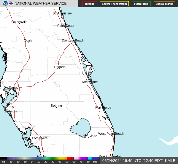
Hotter than normal temperatures are forecast Thursday, with highs climbing into the low to mid 90s at the coast and mid to upper 90s across the interior, with peak heat indices between 102 to 107 across east central Florida, according to the National Weather Service Melbourne.
Hot temperatures will continue from late week and into the weekend, with near record highs well into the 90s and peak heat indices of 100 to 107.
-
Thursday: A 30 percent chance of showers and thunderstorms after 3 p.m. Increasing clouds, with a high near 92. South wind 5 to 10 mph becoming east southeast in the afternoon.
-
Friday: A 50 percent chance of showers and thunderstorms after 2 p.m. Mostly sunny, with a high near 91. Southwest wind 5 to 10 mph. New rainfall amounts of less than a tenth of an inch, except higher amounts possible in thunderstorms.
-
Saturday: A 20 percent chance of showers and thunderstorms after 2 p.m. Sunny, with a high near 90. West wind 5 to 10 mph becoming east northeast in the afternoon.
-
Sunday: Sunny, with a high near 94. West wind 5 to 10 mph becoming east in the afternoon.
Follow the National Weather Service Melbourne on X, formerly known as Twitter
Hotter than normal temperatures are forecast Thursday, with highs climbing into the low to mid 90s at the coast and mid to upper 90s across the interior, with peak heat indices between 102 to 107 across east central Florida, according to the National Weather Service Melbourne.
Hot temperatures will continue from late week and into the weekend, with near record highs well into the 90s and peak heat indices of 100 to 107.
-
Thursday: A 30 percent chance of showers and thunderstorms, mainly after 3 p.m. Mostly sunny, with a high near 93. Heat index values as high as 105. South wind 5 to 15 mph becoming east southeast in the afternoon.
-
Friday: A 50 percent chance of showers and thunderstorms after 2 p.m. Sunny, with a high near 92. Heat index values as high as 103. Southwest wind 5 to 10 mph becoming south southeast in the afternoon. New rainfall amounts of less than a tenth of an inch, except higher amounts possible in thunderstorms.
-
Saturday: A 20 percent chance of showers and thunderstorms after 2 p.m. Sunny, with a high near 93. West wind 5 to 10 mph becoming east in the afternoon.
-
Sunday: A 20 percent chance of showers and thunderstorms after 2 p.m. Sunny, with a high near 94. West southwest wind 5 to 10 mph becoming east southeast in the afternoon.
Follow the National Weather Service Melbourne on X, formerly known as Twitter
Hotter than normal temperatures are forecast Thursday, with highs climbing into the low to mid 90s at the coast and mid to upper 90s across the interior, with peak heat indices between 102 to 107 across east central Florida, according to the National Weather Service Melbourne.
Hot temperatures will continue from late week and into the weekend, with near record highs well into the 90s and peak heat indices of 100 to 107.
-
Thursday: A 30 percent chance of showers and thunderstorms, mainly after 3 p.m. Mostly sunny, with a high near 94. Heat index values as high as 103. Light and variable wind becoming east southeast 5 to 10 mph in the afternoon.
-
Friday: A 50 percent chance of showers and thunderstorms after 2 p.m. Mostly sunny, with a high near 94. Heat index values as high as 102. Light southwest wind becoming south southwest 5 to 10 mph in the afternoon. New rainfall amounts of less than a tenth of an inch, except higher amounts possible in thunderstorms.
-
Saturday: A 30 percent chance of showers and thunderstorms after 2 p.m. Sunny and hot, with a high near 95. Calm wind becoming southeast around 5 mph in the afternoon.
-
Sunday: A 20 percent chance of showers and thunderstorms after 2 p.m. Sunny and hot, with a high near 95. Light and variable wind becoming south southeast 5 to 10 mph in the afternoon.
Follow the National Weather Service Melbourne on X, formerly known as Twitter
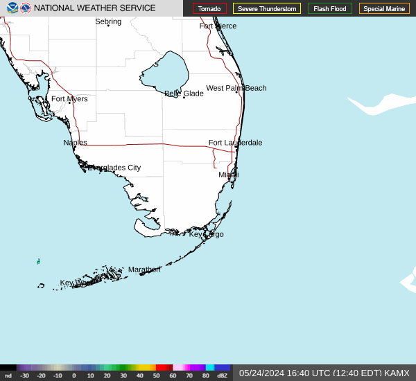
Isolated to scattered thunderstorms will develop Thursday, especially over interior and lake region areas The primary threats are frequent lightning strikes and gusty winds. Heat indices could approach or slightly exceed triple digits over portions of South Florida, according to the National Weather Service Miami.
For Friday through Wednesday, showers and thunderstorms will be possible each day, with the greatest coverage expected each afternoon over the interior. Temperatures will increase through the end of the week and into the weekend, with some locations approaching advisory criteria at times.
-
Thursday: A 20 percent chance of showers and thunderstorms after 3 p.m. Mostly cloudy, then gradually becoming sunny, with a high near 87. Heat index values as high as 103. Light southwest wind becoming southeast 8 to 13 mph in the morning.
-
Friday: Showers and thunderstorms likely, mainly after 2 p.m. Mostly sunny, with a high near 88. Heat index values as high as 103. Southwest wind 6 to 13 mph becoming southeast in the afternoon. Chance of precipitation is 60%. New rainfall amounts between a tenth and quarter of an inch, except higher amounts possible in thunderstorms.
-
Saturday: A chance of showers before 11 a.m., then a chance of showers and thunderstorms between 11 a.m. and 2 p.m., then showers likely and possibly a thunderstorm after 2 p.m. Sunny, with a high near 89. West wind 7 to 11 mph becoming southeast in the afternoon. Chance of precipitation is 70%.
-
Sunday: Showers and thunderstorms likely, mainly after 2 p.m. Sunny, with a high near 89. West wind 8 to 13 mph becoming southeast in the afternoon. Chance of precipitation is 60%.
Follow the National Weather Service Miami on X, formerly known as Twitter
Daily isolated to scattered showers and thunderstorms are forecast over the weekend. High temperatures could reach the mid to upper 90s each day, with areas in the interior potentially topping out in the triple digits. Heat indices will likewise climb into the mid 100s for most areas, according to the National Weather Service Miami.
Models are showing a potential for a tropical disturbance to form in the Caribbean early next week, which would have the potential to impact the region at some point. However, uncertainty is very high. There is a potential for the disturbance to impact parts of South Florida, while other models show no impactful weather. “This potential system needs to be taken with a grain of salt for now, but if it continues to show signs of materializing in future guidance and has a chance to pose threats to South Florida, then potential impacts will be described.”
-
Thursday: Sunny, with a high near 92. Heat index values as high as 108. Light and variable wind becoming southwest 5 to 10 mph in the afternoon.
-
Friday: A 50 percent chance of showers and thunderstorms, mainly after 11 a.m. Mostly sunny, with a high near 91. Heat index values as high as 105. Light south wind becoming southwest 5 to 10 mph in the morning. New rainfall amounts of less than a tenth of an inch, except higher amounts possible in thunderstorms.
-
Saturday: A chance of showers, then showers and thunderstorms likely after 11 a.m. Sunny, with a high near 91. Light northwest wind becoming west 5 to 10 mph in the morning. Chance of precipitation is 60%.
-
Sunday: A chance of showers and thunderstorms, then showers likely and possibly a thunderstorm after 2 p.m. Sunny, with a high near 91. Light west wind increasing to 5 to 10 mph in the morning. Chance of precipitation is 60%.
Follow the National Weather Service Miami on X, formerly known as Twitter
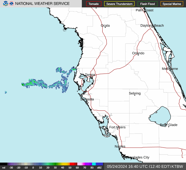
There’s a chance of storms will be inland in the late afternoon and evening hours Thursday. Expect near record heat across much of the area. Rain chances increase starting Friday, according to the National Weather Service Tampa Bay.
Early next week, tropical moisture from the Caribbean will start to lift over the state. Storms chances will start to increase on Monday but the highest chances will be Tuesday and Wednesday.
-
Thursday: Scattered showers and thunderstorms, mainly after 4 p.m. Sunny and hot, with a high near 96. Heat index values as high as 104. Calm wind becoming west southwest 5 to 9 mph in the afternoon. Chance of precipitation is 30%.
-
Friday: Scattered showers and thunderstorms, then showers likely and possibly a thunderstorm after 2 p.m. Sunny, with a high near 93. Heat index values as high as 104. Light and variable wind becoming west southwest 5 to 10 mph in the morning. Chance of precipitation is 60%. New rainfall amounts between a tenth and quarter of an inch, except higher amounts possible in thunderstorms.
-
Saturday: Scattered showers and thunderstorms. Sunny, with a high near 94. Calm wind becoming west southwest 5 to 9 mph in the morning. Chance of precipitation is 50%.
-
Sunday: Scattered showers and thunderstorms after 8 a.m. Sunny, with a high near 93. Calm wind becoming west southwest 5 to 9 mph in the morning. Chance of precipitation is 50%.
Follow the National Weather Service Tampa Bay on X, formerly known as Twitter
Expect an increase in showers Thursday. Inland storms could bring hail and gusty winds. Near record highs are forecast for the area, according to the National Weather Service Tampa Bay. Rain chances increase starting Friday.
Early next week, tropical moisture from the Caribbean will start to lift over the state. Storms chances will start to increase on Monday but the highest chances will be Tuesday and Wednesday.
-
Thursday: Scattered showers and thunderstorms, mainly after 2 p.m. Sunny, with a high near 91. Heat index values as high as 103. Light and variable wind becoming west southwest 5 to 10 mph in the morning. Chance of precipitation is 40%.
-
Friday: Scattered showers and thunderstorms. Mostly sunny, with a high near 87. Heat index values as high as 101. West southwest wind 6 to 14 mph. Chance of precipitation is 50%. New rainfall amounts of less than a tenth of an inch, except higher amounts possible in thunderstorms.
-
Saturday: Scattered showers and thunderstorms, mainly after 2 p.m. Sunny, with a high near 88. West wind 6 to 13 mph. Chance of precipitation is 30%.
-
Sunday: Scattered showers and thunderstorms, mainly after 2 p.m. Sunny, with a high near 88. West wind 6 to 13 mph. Chance of precipitation is 30%.
Follow the National Weather Service Tampa Bay on X, formerly known as Twitter
This article originally appeared on Treasure Coast Newspapers: Florida weather forecast: Record heat, tropical moisture
Signup bonus from