A Flood Advisory has been issued for Darke, Preble counties until 11 p.m.
A Flood Advisory has been issued for Wayne County, Indiana, until 10:15 p.m.
A Flash Flood Warning has been issued for Logan County until 8:45 p.m.
QUICK-LOOK FORECAST:
>>TRACK THE LATEST CONDITIONS: Live Doppler 7 Radar
Storm Center 7 Chief Meteorologist Austin Chaney will have the latest on what we’re tracking LIVE on News Center 7 beginning at 5:00.
DETAILED FORECAST:
THIS EVENING: Partly cloudy with scattered thunderstorms through this evening. Activity starts to wind down closer to midnight. An isolated storm may be strong to severe with damaging wind the primary concern. Any storm could produce very heavy rainfall and frequent cloud to ground lightening. Temperatures in the low 80s this evening cooling to the mid-60s at night.

THURSDAY: A secondary cold front swings through the Miami Valley, which may bring a few light showers during morning. More sunshine returns in the afternoon. Highs around 80 degrees. Breezy. The cold front will drop humidity levels during the day and draw in cooler air by tonight as lows fall to the mid-and upper 50s.
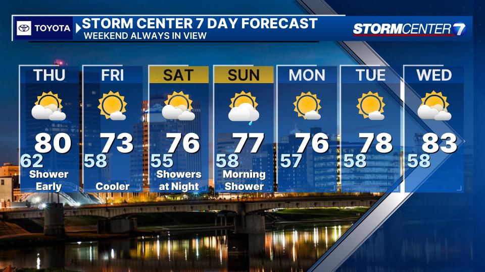
FRIDAY: Partly cloudy and mainly dry. An isolated shower can’t be ruled out especially farther north. Cooler with highs in the lower 70s.
SATURDAY: Partly cloudy skies. Highs in the mid to upper 70s. A few showers may pass through late Saturday night into early Sunday.
SUNDAY: A passing sprinkle or light shower is possible early. Partly cloudy for the afternoon. Highs in the mid- to upper 70s.
MONDAY: Trending drier. Partly cloudy and mild with highs in the mid-70s.
TUESDAY: Partly cloudy, warm with highs in the upper 70s.
WEDNESDAY: Partly cloudy and warm with highs in the lower 80s.
Signup bonus from