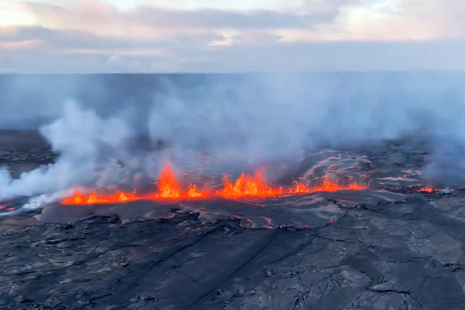
Kīlauea greeted Monday’s early morning darkness with a slow-bubbling eruption that, so far, has posed no threat to communities on the Big Island of Hawaii, officials said.
The volcano, Hawaii’s second largest next to neighbor Mauna Loa, started erupting through four scratch-like fissures about 12:30 a.m. in an area 2.5 miles southwest of its caldera, the U.S. Geological Survey said.
By Monday afternoon, only one of the fissures, one slightly more than a half-mile long, was active, the agency said. The USGS and the Hawaii County Civil Defense Agency said the Big Island’s volcano threat level was downgraded from warning to watch, meaning an eruption with limited hazards is underway.
The location at Hawaii Volcanoes National Park is within a zone surrounding the caldera that has been closed since early 2008, when sulfur dioxide emissions and an eruption triggered safety concerns.
It’s remote enough that officials don’t expect threats to Big Island communities.
“This eruption could end without producing much lava,” the USGS said in an update Monday afternoon.
Federal geologists compared the eruption to one in the same location in December 1974 that lasted six hours. “Fissures from this eruption have the same orientation,” the USGS said in its update.
The eruption took place within Hawaii Volcanoes National Park, under the watchful gaze of seismometers, GPS monitors, tiltmeters, infrasound gauges, gas detectors and thermal and visual cameras maintained by the Hilo-based Hawaiian Volcano Observatory.
The federal observatory’s scientist-in-charge Ken Hon told NBC affiliate KHNL of Honolulu, “This was a real sneaky eruption.”
Still, it didn’t come without some of those 200 sensors sounding off. The USGS said in its latest update that the eruption was accompanied by more than 400 small earthquakes since the weekend, including a magnitude-4.0 earthquake at 7:07 p.m. Sunday, tiltmeter readings indicating significant ground deformation and elevated sulfur dioxide gas emission rates.
And the federal scientists in Hilo knew something was afoot. “Rates of seismicity and deformation increased greatly after 5:00 p.m. on June 2, prompting the USGS Hawaiian Volcano Observatory to raise Kīlauea’s alert level,” the USGS said in its update.
Gas emissions remained the primary concern, the agency said.
The National Park Service said some areas of Hawaiʻi Volcanoes National Park are closed, including Maunaiki Trail, a remote, 7-mile path near Kīlauea, a stretch of Hilina Pali Road, Kulanaokuaiki Campground, Pepeiao Cabin, Kaʻaha Trail and campground, and the Kaʻū Desert Trail and pullout on Highway 11.
A USGS primer on Hawaii volcanoes said Kīlauea is an overachiever, having erupted “almost continuously” from 1983 to 2018. It last erupted in September.
This article was originally published on NBCNews.com
Signup bonus from