Day 2 of the 2024 Atlantic Hurricane Season is much like day one: a few tropical waves are being tracked but no development of tropical cyclones is expected in the next 7 days, according to the National Hurricane Center’s Sunday morning outlook.
The season is expected to be a very active one, with the National Hurricane Center and all other meteorological outlets seeing potential records set for named storms.
National Hurricane Center is tracking four tropical waves, according to the latest tropical discussion.
With no tropical storms on the horizon and a clear day for most places in the Florida Peninsula, it’s a good time to prepare. June 1-14 are sales tax holidays throughout Florida.
For Sunday, mild weather, in the low-to-mid 80s, is expected in Florida’s coastal Panhandle and along much of the Atlantic coast, while hotter temperatures are forecast for the Florida Peninsula’s Gulf coast and central areas.
The Atlantic hurricane season starts Saturday, June 1. The season ends Nov. 30.
The Atlantic basin includes the northern Atlantic Ocean, Caribbean Sea and Gulf of Mexico.
The National Hurricane Center also was tracking four tropical waves Sunday, June 2. Here’s the latest update from the NHC as of 8 a.m. June 2:
What is out there and where are they going?

-
Tropical wave 1: An tropical wave is emerging off the coast of Africa southward, moving west at around 17 mph with some scattered moderate to strong convection.
-
Tropical wave 2: A central Atlantic tropical wave is moving west at 17 mph and faster. Widely scattered moderate convection is also noted.
-
Tropical wave 3: Another Atlantic tropical wave is over Barbados, moving west around 17 mph with scattered moderate convection.
-
Tropical wave 4: A central Caribbean tropical wave is being tracked near the Cayman Islands southward to western Panama, moving west around 11 mph. Widely scattered showers are near the Cayman Islands and Island of Youth, with some moderate convection.
Who is likely to be impacted?
It’s too early at this time to determine if there will be any impact to Florida or the U.S. from the tropical waves.
Forecasters urge all residents to continue monitoring the tropics and to always be prepared. That advice is particularly important for what is expected to be a very active hurricane season.
Names for the 2024 Atlantic hurricane season were last used in 2018 and will be used again in 2030 unless any are retired and replaced by the WMO.
Here are the 2024 hurricane names:
-
Alberto
-
Beryl
-
Chris
-
Debby
-
Ernesto
-
Francine
-
Gordon
-
Helene
-
Isaac
-
Joyce
-
Kirk
-
Leslie
-
Milton
-
Nadine
-
Oscar
-
Patty
-
Rafael
-
Sara
-
Tony
-
Valerie
-
William
Weather watches and warnings issued in Florida
When is the peak of hurricane season?
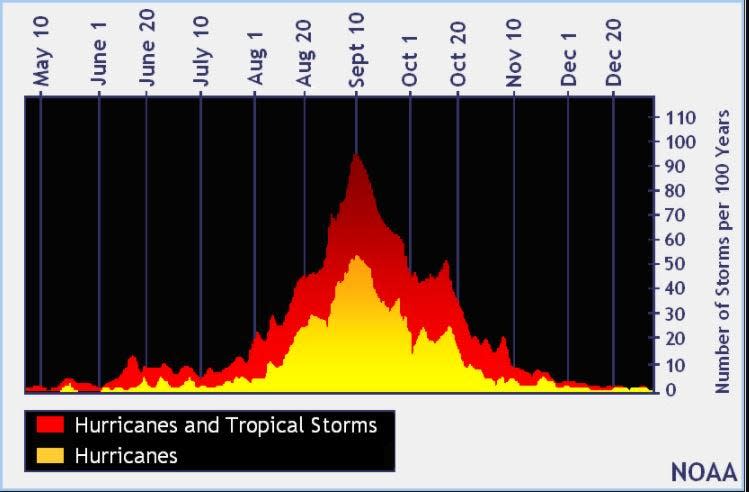
The peak of the season is Sept. 10, with the most activity happening between mid-August and mid-October, according to the Hurricane Center.
NOAA predicting up to 25 named storms in 2024 hurricane season

Except two tropical disturbances — one southeast of Florida earlier this month and another in April — it’s been a quiet start to what is predicted to be a very active season that could double the average number of storms. AccuWeather predicted 2024 could top the 2020 record of 30 named storms.
NOAA is predicting there is an 85% chance of an above-normal season.
NOAA’s prediction:
-
17-25 named storms
-
8-13 hurricanes
-
4-7 major hurricanes
A major hurricane is a Category 3 storm or higher, with maximum sustained winds of at least 111 mph.
Two conditions in the Atlantic basin are the reason for the above-average predictions for the 2024 hurricane season: La Niña and record-warm water. Both help the development of storms.
National Hurricane Center map: What are forecasters watching now?
Systems currently being monitored by the National Hurricane Center include:

Noaa
Embedded content: https://www.nhc.noaa.gov/xgtwo/two_atl_0d0.png?052051
Excessive rainfall forecast
What’s next?
We will continue to update our tropical weather coverage daily. Download your local site’s app to ensure you’re always connected to the news. And look for our special subscription offers here.
This article originally appeared on Naples Daily News: Hurricane season 2024: NHC tracking waves in Atlantic, Caribbean
Signup bonus from