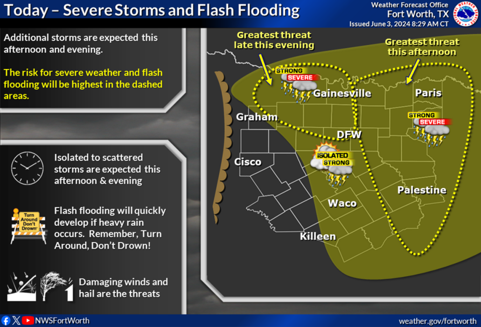
More large hail, damaging winds and flash flooding are possible Monday as another line of storms hit Dallas-Fort Worth, according to the National Weather Service Fort Worth office.
North Texans have seen storms nearly everyday for the past week. An EF-3 tornado with maximum winds of 140 mph landed in Denton and Cooke counties over Memorial Day weekend. A series of storms last week, knocked out power for over 600,000 in the region.
Monday has a chance for strong to severe storms over the afternoon and evening hours, said Juan Hernandez, meteorologist at the NWS Fort Worth office.
The NWS forecast shows arriving in the Metroplex from noon to 3 p.m. Another round of storms is possible this evening around midnight, Hernandez said.
The main threats with the storms on Monday will be large hail, damaging winds and flash flooding.
⚡ More trending stories from our newsroom:
→ Video: Lightning strikes truck on I-35 in Fort Worth. “I was in shock”
→ Fort Worth increases property tax breaks for seniors
→ Want to visit new Palo Pinto state park? You’ll have to wait.
After Monday, North Texas could potentially see another round of storms late Tuesday into early Wednesday, Hernandez said.
Due to the storms over the past week, much of North Texas are saturated and its reservoirs full. This brings an increase in potential localized flash flooding to the Metroplex, Hernandez said.
It’s important for drivers to stay alert while driving through storms and to never drive on a road that has water flowing on it.
“Turn around don’t drown,” Hernandez said.
Signup bonus from