The Latest Northeast Wisconsin Forecast from Storm Team 5…
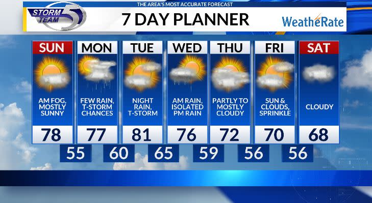
Happy First Day of Meteorological Summer! Light rain moved through the area during the late morning to early afternoon, but things have cleared up a bit for any Saturday evening plans. As winds go calm and the rain evaporates, do plan for fog to develop tonight into early tomorrow. Lows fall into the low to mid 50s.
The fog will burn off by 9-10am and once that occurs, mostly sunny skies will emerge with temperatures into the mid and upper 70s to near 80 in some spots, although cooler lakeside with a southeast wind. Overall, beautiful weather for the 25th Pet Walk Green Bay! Overnight a few clouds and lows into the mid 50s.

This will be the last fully dry day for a few days as multiple rain chances enter the picture. A few chances of showers and thunderstorms arrive for Monday. High temperatures into the mid and upper 70s, and will be humid also with dew points into the low 60s.
Tuesday will feature partly cloudy skies with temperatures into the upper 70s and low 80. It will be warm, and very humid with dew points into the upper 60s. As for rain, looks like the daylight hours are dry besides an isolated shower or two. The best chance for any wet weather looks to now hold off into Tuesday night and lasts through Wednesday morning as showers and thunderstorms roll through.
Wednesday mid day looks dry before a weak disturbance flares up a few afternoon isolated showers. Temperatures for your Wednesday begin a cool down into the middle 70s.
Copyright 2024 Nexstar Media, Inc. All rights reserved. This material may not be published, broadcast, rewritten, or redistributed.
Signup bonus from