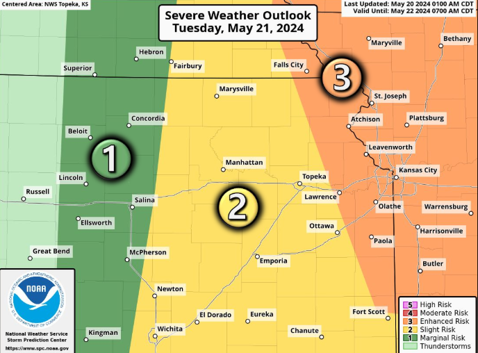
Large hail and damaging winds will be the primary threats for severe weather expected Tuesday afternoon to affect northeast Kansas, the National Weather Service says.
Topeka is part of an area forecast to see a “slight” chance of severe weather while Lawrence is part of an area expected to see an “enhanced” chance, said a graphic posted on the website of the weather service’s Topeka office. An “enhanced” risk brings a higher possibility of severe weather than a “slight” risk.
“A few” tornadoes can’t be ruled out, with the greatest possibility for those being east of US-75 highway, the weather service said.
Forecasters expressed “medium” confidence” that severe thunderstorms would form. They said the storms would most likely move through the area from the west to east between mid- to late afternoon and sunset.
What happened Sunday evening?
Tuesday’s chances for severe weather come after storms bringing high winds and hail swept late Sunday through central and eastern Kansas. The storms brought 100-mph winds and golf ball-sized hail to Salina in north-central Kansas.
In the area surrounding Topeka, the weather service said, Sunday evening’s storms brought reports of wind damage to trees at Auburn and two miles south of Meriden; downed power lines one mile south of Scranton; 70-mph gusts at Oskaloosa; and 60-mph gusts two miles northeast of Dover and two miles southeast of Pauline.
Power outages caused by Sunday evening’s storms affected a peak of 93,000 customers in the parts of Kansas and Missouri served by Evergy, that electrical utility said in a statement posted Monday on the website of its online power outage map.
“Vegetation and line crews are working on power restoration and support teams are assessing damage,” it said. “Restoration times will be delayed and estimates are not yet available.”
More than 3,000 homes and businesses remained without electrical power Monday morning in Topeka, with most of those being in the southwest part of the city, the Evergy outage map said.
Three tornado warnings were issued late Sunday affecting parts of Shawnee County.
The weather service Monday morning was seeking to determine if any tornadoes had touched down, but no twister damage having been found as of 9 a.m., said John Woynick, meteorologist for the weather service office in Topeka.
Will Monday bring severe weather?
The weather service predicted most of north-central and northeast Kansas would see a “marginal” risk for severe weather after 8 p.m. Monday, though it said that risk would be “slight” in an area long and north of US-36 highway.
A “slight” risk brings a high possibility of severe weather than a “marginal” risk.
Forecasters had “low” confidence in the possibility severe storms would develop, Monday evening said the website of the weather service’s Topeka office.
If severe storms do develop, it said, they would most likely involve wind gusts around 60 mph and hail around the size of quarters.
Contact Tim Hrenchir at threnchir@gannett.com or 785-213-5934.
This article originally appeared on Topeka Capital-Journal: Hail, high winds anticipated Tuesday afternoon for northeast Kansas
Signup bonus from