AUSTIN (KXAN) — The following flood advisories are in effect:
Lampasas Co. is under a Flood Warning until 9 a.m.
Rain totals this weekend are averaging .50″ up to several locations with 1.00″ to 1.50″, especially in the Hill Country. Camp Mabry measured 1.14″ between 2 and 4 a.m.
The Flood Watch remains in effect through early this afternoon.
Many rain totals of 1 to 3″ since late Wednesday night
While the threat of severe weather has decreased this morning there will still be a chance of a few more showers and thunderstorms later today.
As a result, the Storm Prediction Center has part of our area under a Marginal risk (Category 1 out of 5) for severe thunderstorms. Small sections of Blanco, Caldwell, and Hays Counties are under a Slight risk.
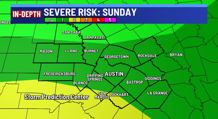
Most of our storm threats today will come from hail up to 1″ (the size of a quarter) and wind gusts up to 58+ mph.
In addition, the majority of the region will remain under a Slight risk (Category 2 of 4) for pockets of heavy rain leading to flash flooding.
There will be a 10% chance of a few isolated showers/storms Monday, then again Thursday, Friday, and Saturday. Any rain during this time will measure out to a few hundredths up to .25″.
Some highs hit the low 90s Tuesday and Wednesday. A cold front arrives overnight Thursday to Friday leaving a northeast winds that lowers temperatures Friday and Saturday.
NEW BLOG: May forecast: Will our rainiest month live up to it?
BLOG: Here’s when El Niño ends and La Niña begins
BLOG: La Niña Watch Issued: Here’s the impact on Central Texas
FIRST WARNING WEATHER: Stay up to date with your Central Texas forecast, sign up for our weather newsletter at kxan.com/newsletters
Stay up-to-date with the First Warning Weather team
Follow the KXAN First Warning Weather team on Facebook, Twitter and Instagram.
You can also follow our meteorologists’ individual accounts for livestreams and a little bit of what goes on behind the scenes:
For the latest news, weather, sports, and streaming video, head to KXAN Austin.
Signup bonus from