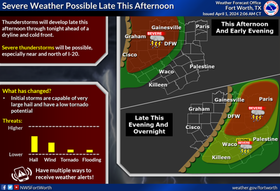
Severe thunderstorms capable of producing large hail and damaging winds could arrive in North Texas as early as 4 p.m. Monday, according to the National Weather Service Fort Worth office. Storms will move east and southeast over the Metroplex by the afternoon and evening.

Cities west of the Metroplex such as Bowie, Jacksboro and Mineral Wells could see storms as early as 4 p.m. The most likely time for storms to hit the area is between 5 and 7 p.m., with the threat ending by 9 p.m.
For Dallas-Fort Worth, storms could start as early as 6 p.m. Storms are most likely to hit from 7 to 10 p.m. and end by 11 p.m.
Eastern Metroplex cities such as Terrell and Corsicana could see storms as early as 9 p.m. Storms are most likely to hit from 10 p.m. to 1 a.m. and end by 2 p.m.
⚡ More trending stories:
→ There’s no ‘better place’ to see April 8 total solar eclipse than in this tiny Texas town.
→In Texas, set your thermostat at 80 when it’s 100 degrees, expert says.
→Groceries at this national chain are the cheapest, study finds.
This line of storms will be pushed into North Texas after the lifting of a cap — a layer of warm air up high in the atmosphere which suppresses or delays the development of thunderstorms.
Large hail and damaging winds will be the main threats for North Texans on Monday, along with low tornado threats. Atmospheric conditions could support hail as large as three inches in diameter, according to the NWS.
Although the forecast calls for a lower threat of tornadoes, North Texas is entering its season of severe weather. Historically, April and May are the months where North Texas records its highest tornado activity.
After the storms Monday, North Texas will enter a dry spell for the rest of the week.
Tuesday’s high is in the upper 60s, followed by mid to high 70s for Wednesday, Thursday and Friday. Winds will increase over the weekend, leading to possible cloudy and rainy weather for the total solar eclipse on April 8.
Signup bonus from