THE FOLLOWING WATCHES HAVE BEEN ISSUED:
Several rounds of scattered showers, some of which can be on the heavy side, are expected over the next several days. Prolonged rainfall can pose a risk for areas with poor drainage systems and cause our rivers to run high so remember if you see high water to #TurnAroundDontDrown!

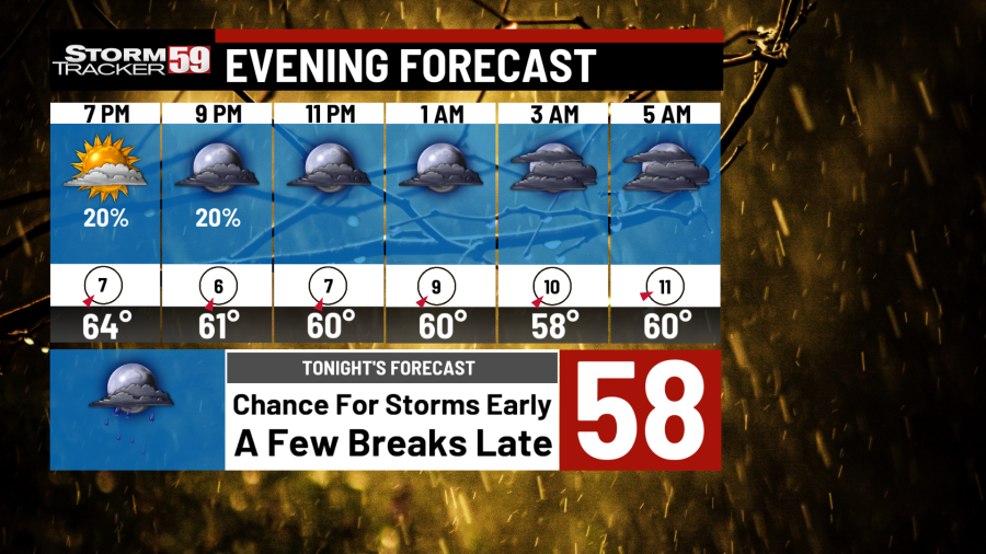
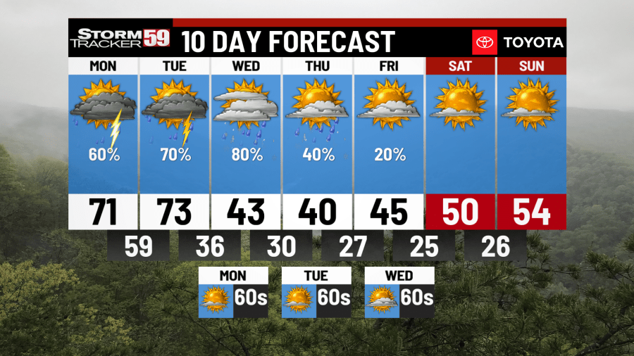
Tonight, the chance for a few storms will be around this early evening and overnight. However, towards and after midnight, much the area will develop a lull in the activity, seeing partly cloudy to mostly cloudy skies. It will be a warm overnight with lows dropping into the low 60s, upper 50s.
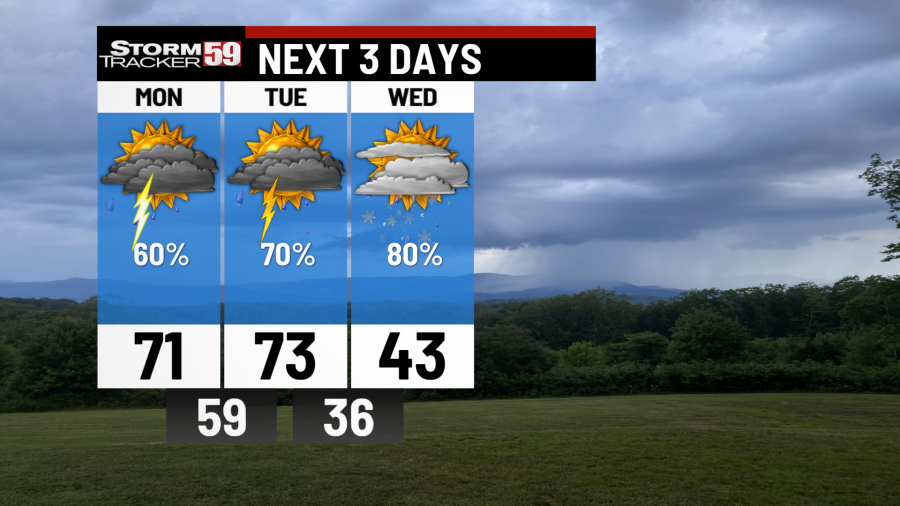
Monday morning starts with the chance for rain showers with temps in the 50s. The chance of rain looks like a good bet for your Monday, with some showers being on the heavy side. Towards lunchtime and into the afternoon, we’ll see scattered showers and thunderstorms develop. Some of the storms can be on the strong side with damaging winds and hail being the biggest risks.
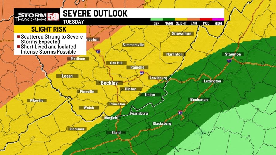
Tuesday brings in a cold front, creating chances for more scattered showers and thunderstorms, especially in the afternoon. We’ll start the morning with some showers, building in coverage toward the afternoon as our system crosses with damaging winds and hail being the biggest threats, though an isolated tornado or two is also possible. We’ll also have to watch for the chance for some heavy rain showers. Temps on Tuesday will once again be in the 70s.

Wednesday will be a much colder day with northwest winds pushing through after the passage of the cold front. We start the morning only in the 30s and only get into the 40s later in the afternoon. Periods of light drizzle and even the chance for some snow showers look likely, especially across the mountains.
Thursday won’t be much better with temps still sticking in the 40s in the afternoon, that’s after a cold morning in the 30s. The chance for snow showers will still be possible across the lowlands and mountains but they’ll start to diminish in coverage during the afternoon and overnight as our passing low moves off to the east.
Friday morning is another cold start in the 20s with a few lingering snowflakes across the mountains. Any more snow chances should wrap up during the overnight, but our afternoon temps will stay cold in the middle 40s. Clouds will be tough to clear in the mountains, but the lowlands should see some sunshine to wrap up the afternoon.
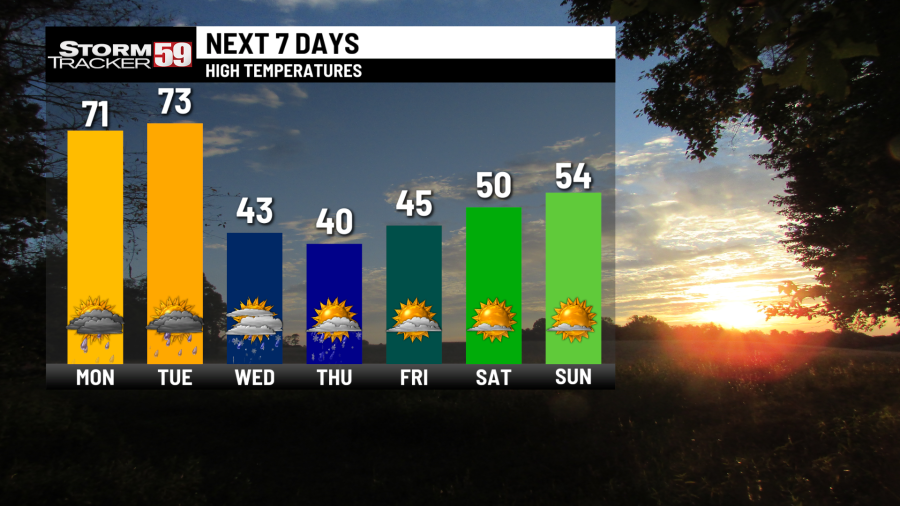
Saturday sees a high pressure system build in, bringing back the dry weather we’ve missed so much. Mostly sunny skies are expected for Saturday under slightly warmer temps in the 50s.
In your extended forecast, high pressure will build in next weekend, providing us a break from active weather. Sunny skies and dry weather is expected next weekend and into next week as our temps slowly try to get back into the 50s by next Sunday.
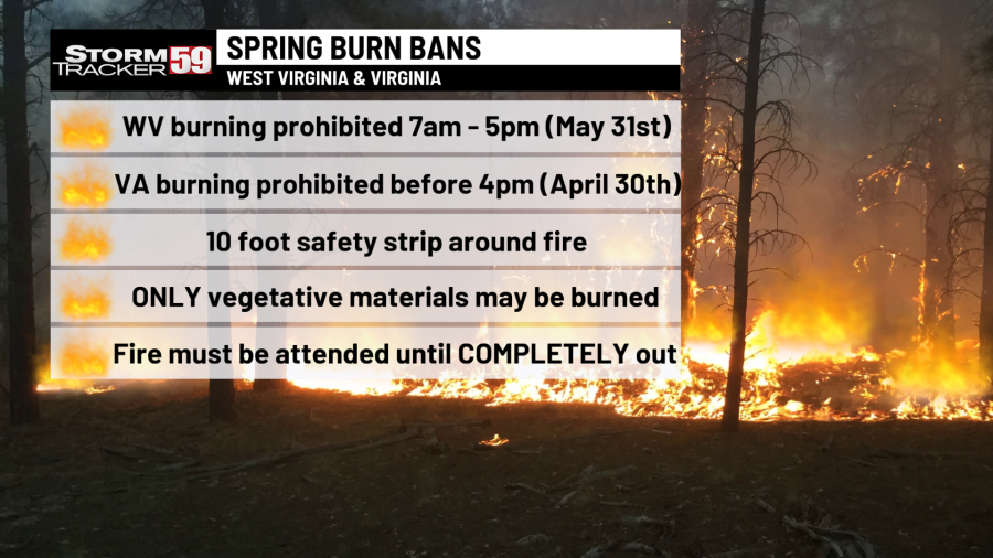
We are in spring forest fire season in West Virginia – this means don’t burn between 7 AM and 5 PM through May 31st. Low humidity values during the daytime, along with breezier and warmer conditions will at times increase the fire threat, hence the burn ban during most of the daytime. Follow all regulations or be faced with potential consequences, such as fines! In Virginia, the spring fire season continues through April 30th – don’t burn before 4 PM.
TONIGHT
Chance for storms early. A few breaks later. Warm. Lows in the 50s.
MONDAY
Scattered showers/storms. A few strong storms possible. Highs in the 70s.
TUESDAY
Scattered storms. More strong storms expected. Highs in the 70s.
WEDNESDAY
Cooler day. Chance for rain and snow. Highs in the 40s.
THURSDAY
Chance for rain and snow again. Cold. Highs in the 40s.
FRIDAY
MTN snowflakes. PM clearing. Highs in the 40s.
SATURDAY
Mostly sunny. Mild. Highs in the 50s.
SUNDAY
Mostly sunny again. Dry afternoon. Highs in the 50s.
MONDAY
Staying sunny. Warming up. Highs in the 60s.
TUESDAY
Staying sunny and staying warm. Highs in the 60s.
WEDNESDAY
A few clouds build in but staying dry. Highs in the 60s.
For the latest news, weather, sports, and streaming video, head to WVNS.
Signup bonus from