(SOUTHERN COLORADO)—A nearby low-pressure system spinning off the coast of California is bringing windy and warm weather to the area. This system is also responsible for a weekend full of high fire danger, including Easter.

Incoming systems, like the one seen above, typically bring a couple of days of unsettled weather to the region. Notice the rain and snow pushing through Nevada and Utah; that energy allows winds to pick up and warm air to surge in from the south.
High winds, warm temperatures, and dry conditions leading to quite an active weekend of elevated fire danger. Here is a look at the expansive red flag warnings for the area.

The red flag warnings extend up and down the I-25 corridor from Trinidad through south Denver and then all of the eastern plains south of I-70. The dry conditions are a big problem for adding fuel to the fire – so to speak.

Dewpoints tomorrow will be in the upper teens and middle 20s for most of the afternoon. Relative humidities will be below 20% at times for several different areas. Most of the moisture, you can see in the green, hanging out well to our east.
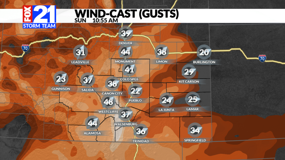

Winds throughout the morning and afternoon will allow for rapid fire spread, should anything spark up. Gusts of up to 50 mph will be possible throughout the day. Plan on a windy Sunday for everyone.
Once the system passes through, a trailing cold front will significantly alter our temperatures for the start of the work week.


This cold front will knock most of southern Colorado back a good 20 degrees. In addition to everything else, the area is also preparing for some precipitation Sunday night into Monday.

Right now, it looks like the lower elevations will miss out on most of the snow until midday on Monday.
For the latest news, weather, sports, and streaming video, head to FOX21 News Colorado.
Signup bonus from