The Big Bend is expected to have an especially soggy couple of days as a slow-moving system lingers over the area.
Molly Merrifield, meteorologist with the National Weather Service, said the showers and thunderstorms associated with a front are expected to make their way to Tallahassee later Tuesday. Periods of heavy rain are possible.
“Then another round from that same system is supposed to kind of get going again or blossom probably early (Wednesday) morning, into the day,” Merrifield said. “So heavy rainfall will be possible with that also.”
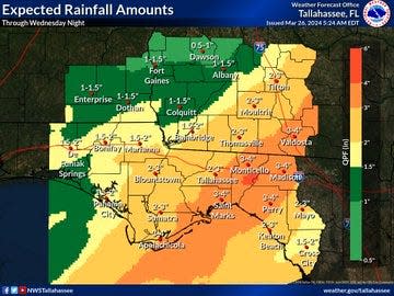
Much of the Big Bend could see 2-4 inches of rain, though higher amounts of 5-6 inches are possible, Merrifield said. There is a marginal risk of severe weather.
“We could see a few strong storms with this,” she said. “We can’t rule out a couple of damaging wind gusts and maybe a weak tornado or two. But really the main threat with this system is going to be the rain.”
The Weather Service in Tallahassee issued a flood watch from Tuesday night through late Wednesday night for Dixie, Franklin, Gulf, Jefferson, Lafayette, Leon, Liberty, Madison, Taylor and Wakulla counties. Flooding of rivers, creeks, streams and other low-lying and flood-prone places is possible.
So far this year, Tallahassee has gotten nearly 13 and a half inches of rain, about a third of an inch higher than normal.
This article originally appeared on Tallahassee Democrat: Flooding possible as heavy rain moves into the Big Bend, north Florida
Signup bonus from