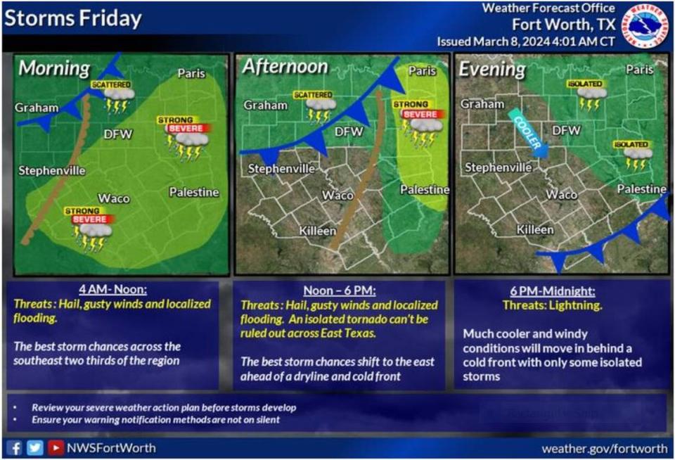
Thunderstorms intensified early Friday morning making the commute into Dallas-Fort Worth a wet and blustery mess. But a cold front expected to arrive later in the day will push all the moisture to the east and will cool things down considerably with patchy frost expected early Sunday in some parts of the region.
“A few of the [storm] cells have intensified and are producing some sub-severe hail,” according to the National Weather Service. “However, a storm or two may intensify enough to prompt a Severe Thunderstorm Warning.”
The NWS did not rule out the possibility of tornadoes east of the Metroplex later Friday afternoon. This is the time of year when twisters tend to form, historical storm data shows.
⚡ More trending stories:
→ Texas to ‘spring forward’: When daylight saving time begins
→ How a six-pack of beer, $100 got rescuers to pull pig out of thorns.
→ Want to make $359K a year working from home? Here’s a list of jobs.
Expect the storms to continue across North Texas through the evening Friday, especially along and east of the I-35 corridor. The storms are expected to gradually end as a surface low pressure system moves across the region, bringing a dryline — a boundary that separates a moist air mass from a dry air mass — and a cold front with it.
It sounds like there will be quite a temperature difference across different regions on Friday, with highs ranging from the 60s in the northwest to around 80 in the southwest, according to the NWS. Friday night is expected to be cold with lows in the upper 30s to mid 40s. Additionally, a strong and gusty northwest wind is likely to make it feel even colder.
“Most of the rain will end with the passage of the cold front during the afternoon, but wrap around moisture associated with the departing upper low could result in scattered, elevated storms north of I-20 Friday evening,” per the NWS. “Hail will be the primary severe weather threat.”
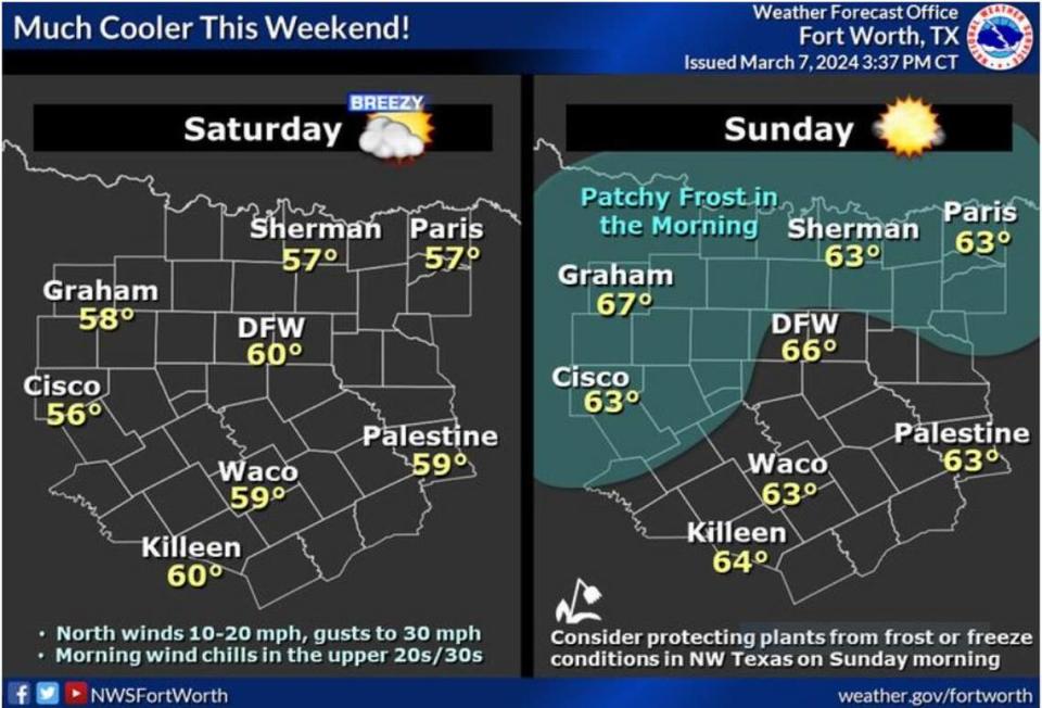
Gusty winds and cooler temperatures are expected behind the front. Overall, the weather will gradually improve throughout the evening and into the weekend as high pressure builds up.
“Lows will fall into the 30s across the majority of the [county warning area] and a few rural spots across the northwest will likely reach freezing for a couple hours in the pre-dawn hours Sunday,” according the NWS. “The cold temperatures and plenty of ground moisture will result in patchy frost, especially across the northern and western zones.”
Signup bonus from