What a busy start to the work week, at least on the weather front!
Monday evening, after a day full of heavy mountain snow, gusty winds, and on/off wintry showers, more of the same is expected overnight into Tuesday morning.
Enhanced convergence to the north continues to be a focal point into Tuesday morning with activity detected from Vancouver Island into Arlington and parts of Snohomish County into parts of King County. These areas will continue to face threats of gusty winds, rain/snow, and hail.
As of 5:40 p.m., there was about a 40% chance of seeing over an inch of snow around Mount Vernon south into Lynnwood and across the Admiralty Inlet by tomorrow morning.
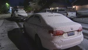
Lingering moisture from weather Monday and overnight creates an additional hazard for drivers Tuesday morning as freezing and subfreezing morning lows will cause icy spots to develop on surface areas/roads.
Outside of convergence zones, showers do taper into tomorrow which should keep surfaces relatively dry.
With more wet weather Tuesday, it’s Wednesday’s system that I’ve got my eye on. That system will bring lowland rain and another round of heavy mountain snow at around 3,500′ at first and then dropping.
By Thursday with showers, the snow level will be around 1,500′ and then lower for the next few days. The wind will also increase nearing or meeting Advisory levels. Localized flooding on the southern slopes of the Olympics is also a concern for Wednesday.
It’s a week full of active weather in Washington so more updates to come!
Signup bonus from