Fort Collins and the Interstate 25 corridor are forecast to see enough snow to make Friday evening’s commute a concern as the latest storm system moves into Colorado.
This is not a major storm, but it could have sneaky impacts along the I-25 corridor depending on where snow bands set up.
Here’s what you need to know regarding the storm’s timing, travel impacts, snowfall forecast and the spring-like warmup that’s expected to follow it.
When snow is expected for Colorado mountains, I-25 corridor
-
Mountains: Snow has already fallen in the mountains. There will be a break Friday morning before snow redevelops Friday afternoon, with an additional 4 to 12 inches possible into Saturday, according to the National Weather Service.
-
I-25 corridor/Eastern Plains: Snow is expected late Friday afternoon, with 3 to 6 inches forecast, making for slick travel conditions that worsen after sunset.
Here are the roads expected to be impacted by the snowstorm
-
Mountains: As of Friday morning, the mountains are already seeing snow-covered roads, including Interstate 70 and U.S. Highway 40.
-
I-25/Eastern Plains: By the Friday evening commute and overnight, there will likely be impacts to I-25 and possibly I-76. Those impacts could last into Saturday.
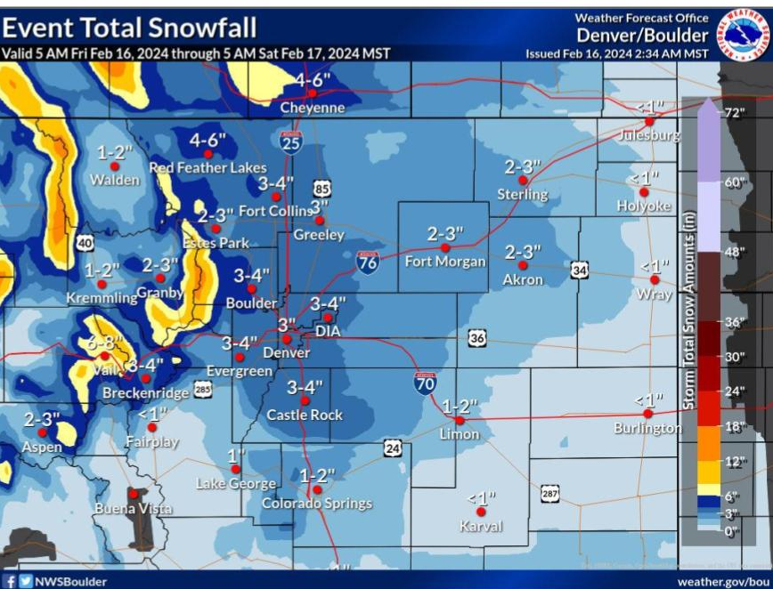
Expected snow totals for Fort Collins and Denver areas, Eastern Plains and Colorado mountains
According to the National Weather Service:
-
Fort Collins: 3 to 4 inches
-
Loveland: 1 to 4 inches
-
Greeley: 2 to 3 inches
-
Windsor: 2 to 3 inches
-
Estes Park: 2 to 3 inches
-
Wellington: 2 to 4 inches
-
Red Feather Lakes: 3 to 5 inches
-
Bear Lake (Rocky Mountain National Park): 4 to 7 inches
-
Cameron Pass: 4 to 8 inches
-
Buckhorn Mountain: 2 to 5 inches
Denver area
Eastern Plains
Mountains
Fort Collins forecast to go from snow and cold to spring-like temperatures
Here is the forecast from the National Weather Service:
-
Friday: 70% chance of snow, mainly after 2 p.m., with daytime accumulation of around 1 inch. High near 32 degrees.
-
Friday night: 70% chance of snow, mainly before 2 a.m., with 2 to 4 inches of new snow possible. Low around 14.
-
Saturday: Patchy fog until mid-morning, with a high near 38 and low around 16.
-
Sunday: Partly sunny, with a high near 50 and low around 28.
-
Monday (Washington’s Birthday): Sunny, with a high near 56 and low around 28.
-
Tuesday: Sunny, with a high near 62 and low around 31.
-
Wednesday: A slight chance of rain. Mostly sunny, with a high near 57 and low around 31.
This article originally appeared on Fort Collins Coloradoan: More snow expected for Colorado, Fort Collins: Friday’s forecast
Signup bonus from