Meteorologists watched for more than a week to see if several weather systems moving across the U.S. would collide next Monday near North Carolina in such way as to create what some here would call the perfect storm.
That’s one that results in 2 to 3 inches of fluffy snow over the state’s midsection.
While it looked possible a week ago that central North Carolina would get the magic meeting of cold dry air from the west or the north and moist air from the south needed to create snow, forecasters now say it’s highly unlikely. They’re not even confident Raleigh will get rain when a low-pressure system moves in from the Southwest Sunday night and Monday, and that system likely will be gone before cold air drops down from the Northeast on Tuesday bringing below-normal temperatures.
Another near miss.
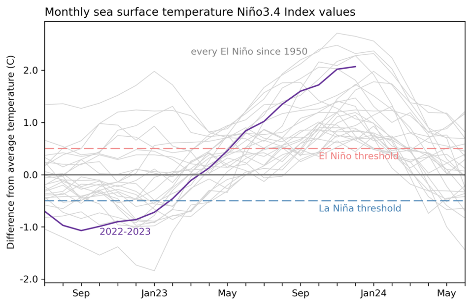
For snow-lovers, it’s all the more frustrating because we’re in the middle of an El Niño, and it’s such a strong one that some are calling it a Super El Niño. That’s not a meteorological classification.
Typically, though not always, an El Niño could be expected to increase the chances of snow in the South through the winter by creating cooler, wetter conditions. But this winter, weather analysts say, other factors, including higher average temperatures globally, have resulted in the South being wetter than normal, but not cooler than normal overall.
During the January cold snap when temperatures did drop below average, it was too dry for snow.
What’s a Super El Niño?
Meteorologists just call it a very strong El Niño, but they say this is one of the strongest on record. Its strength is measured by the deviation from the long-term average in surface water temperatures in a specific area of the tropical Pacific Ocean.
The National Oceanic and Atmospheric Administration said that in November, the temperature was 2 degrees Celsius above the average, and in a January update, it said December readings were 2.1 degrees Celsius (3.6 degrees Fahrenheit) above the 1991-2020 average.
The threshold for a “very strong” El Niño is 2 degrees Celsius above the norm, and to be entered in the record books, it has to apply to a three-month average, so meteorologists are waiting to hear the numbers from January. If the reading is at least 1.9 degrees Celsius above average, it will qualify as one of the five-strongest El Niños in the books.
Is the strong El Niño why we had so much rain?
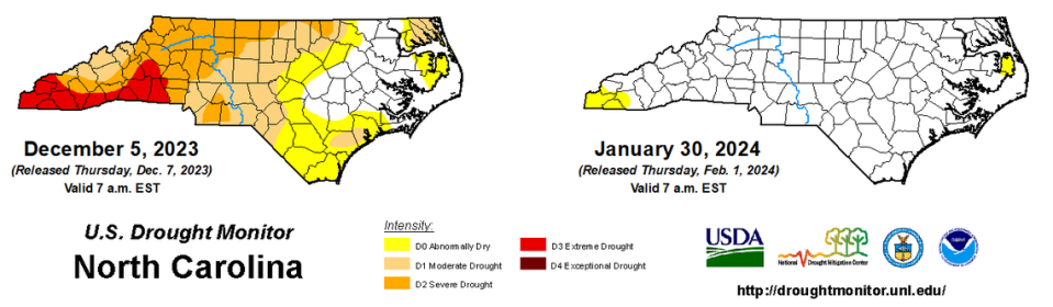
Corey Davis, assistant state climatologist at N.C. State University, says the strong El Niño is to thank for the heavy rains in December and January that nearly wiped out what was a pretty serious, nearly statewide drought through the fall. Going into the winter, Jordan Lake and other major reservoirs were several feet below normal. In mid-January, Jordan was more than 5 feet above what the U.S. Army Corps of Engineers calls full pool.

In the U.S. Drought Monitor’s report issued Thursday, five of the state’s 100 counties remain “abnormally dry,” but none is in drought.
Davis said that for the state as a whole, December was the 7th-wettest on record, and for Raleigh, Greensboro and Wilmington, December was the 2nd-wettest on record.
January: A month of temperature extremes in NC
In his climate blog Thursday, Davis said that despite several days of abnormally low temperatures delivered by an Arctic blast, the average statewide temperature in January was 41 degrees, which is 0.2 degrees above the 1991-2020 average.
It was a month of temperate extremes in the state, with Grandfather Mountain plunging to -5 degrees on January 17 and 21, and the town of Wallace soaring to 84 degrees on Jan. 26.
While January was only the 51st-warmest in North Carolina in 130 years of record-keeping, it was the 27th-wettest on record for the state, according to Davis’ calculations.
And while Raleigh, Durham and Chapel Hill were bereft of snow, Davis said Beech Mountain, the highest town east of the Rocky Mountains, had a total of 37.2 inches of snow in January and Boone had 6.7 inches total for the month.
Most of the rest of the state is experiencing what Davis calls a “snow drought,” since the last measurable snow in most areas was in January 2022, more than two years ago. The runners on our Flexible Flyers have rusted over.

What’s the outlook for February?
It’s still winter until March 19, but temperatures in North Carolina typically begin to rise in February. So while a light snow is not completely out of the question, Davis says, the clock is ticking.
The strength of this El Niño, meteorologists say, means that instead of fading away in February, it’s likely to linger into March or April.
That could be a problem for the state’s farmers, Davis said.
“It might be a case of, ‘Be careful what you wish for,’” he said. After worrying last fall there might not be enough moisture in the soil to plant this spring, Davis said, now, “Come March, they may be wanting the rain to stop so they can a few dry days to get into the fields. There might be a lot of soggy ground out there.”
Signup bonus from