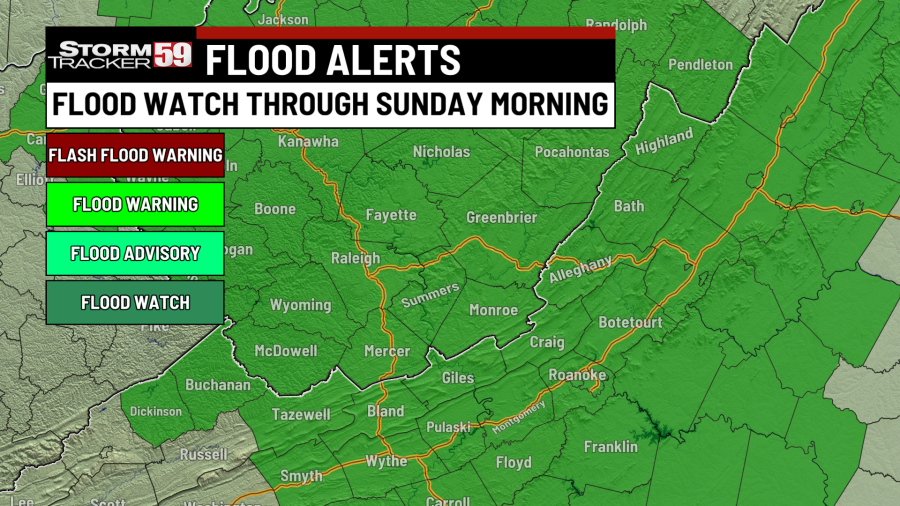
THE FOLLOWING WATCHES/WARNINGS HAVE BEEN ISSUED:
-
Flood Watch for Raleigh, Fayette, Nicholas, Pocahontas, McDowell, Wyoming, Tazwell, Bland, Giles, Mercer, Summers, Monroe, and Greenbrier counties until Sunday morning. Showers tonight can reaggravate our current stream and creek levels, leading to high water issues. If you see any high water, remember to turn around and don’t drown!
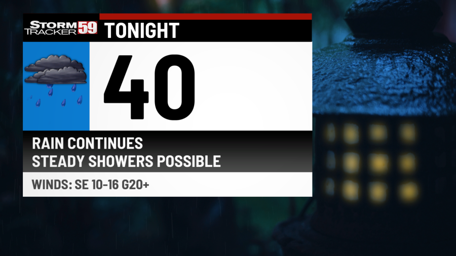
Tonight, scattered showers, some steady at times, will continue to track across the northeast. Not only will this cause issues for anyone traveling out tonight with slick travel and ponding issues, but this will also renew risks of a couple of high water spots, especially across creeks and rivers that will be reaggravated from this past week’s rain. Remember to turn around and don’t drown if you do encounter any high water.
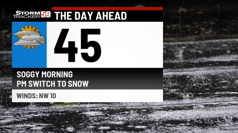
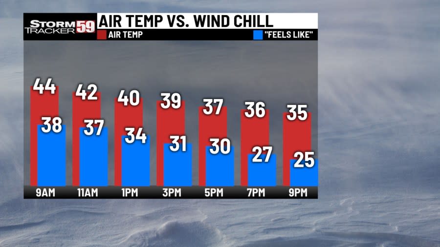
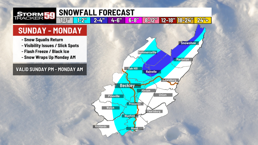
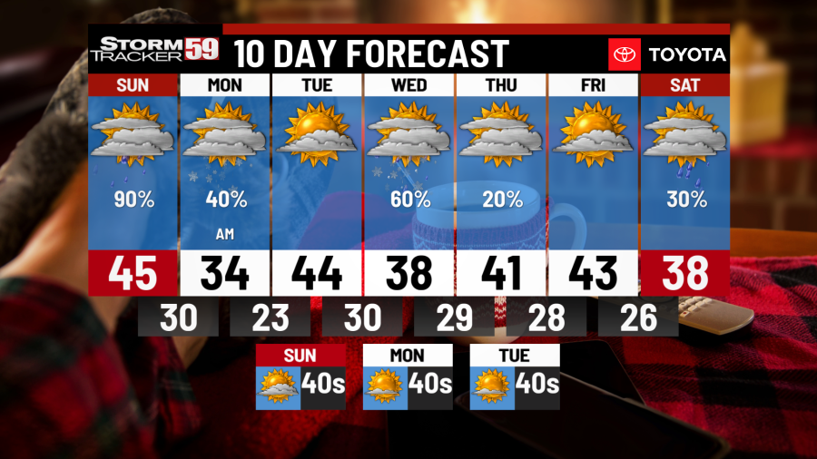
Sunday morning continues with our shower chances as our nearby low pressure system tracks through our area. We’ll be in the 40s for the morning and that will be your high temperature for Sunday. This is because cold, northern air will start to move in, changing our rain to snow during the second half of the day. Accumulations won’t be too impressive through Monday as it primarily stays near the mountains. However, slick travel and reduced visibility will be possible for any heavy rain and/or snow.
Monday takes away our warm trend of the past week as colder air is introduced, dropping our afternoon high into the 30s! Lingering snow will still be possible on Monday, mainly across the mountains. As high pressure is introduced in the afternoon, any lingering snow will diminish by Monday night.
Tuesday starts off with a calm yet cold morning under partly cloudy skies and temperatures in the 20s! After a cold morning, we continue with partly cloudy skies into the afternoon as southern winds warm us up into the 40s! We’ll have a clipper system move through Tuesday night, bringing back rain and snow chances into Wednesday.

Wednesday looks a bit messy as our clipper system moves into the area. Chances for rain and snow will be around on Wednesday, reigniting chances for slick and wet travel commutes. Temperatures will go from near 30 in the morning to near 40 degrees Wednesday afternoon as chances of precipitation taper off overnight.
Thursday looks to bring in a break from the activity again. After a cloudy morning with a few flakes possible across the mountains, we’ll look to bring in some clearing skies as we go into partly cloudy skies by the afternoon and evening. Temperatures look to return near average as we rise into the 40s.
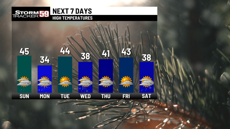
Friday follows a rinse and repeat pattern we’ve seen this week; a calm but cold morning in the 20s! We’ll eventually see the clouds thicken as our next system approaches overnight, bringing in chances for rain and snow again as temperatures rise into the 40s.
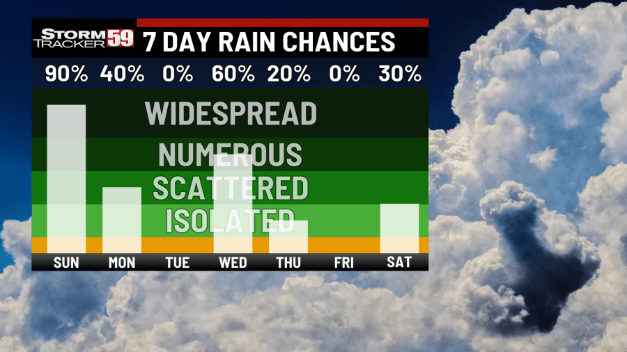
Saturday offers up again the chance for some lingering snow chances. Some fine tuning is still needed for this system, but the chances will be around through the afternoon before diminishing out Saturday night. We’ll be in the 30s Saturday afternoon before temperatures take a tumble into the 20s overnight.
In your extended forecast, we look to be entering a dry pattern once our system leaves on Saturday. Sunday through at least the start of the next week looks to bring back the sunshine and dry weather. Temperatures will be in a little bit of the flux as they go from the 40s into the upper 40s next week.
TONIGHT
Showers, some steady at times. High water possible. Lows in the 40s.
SUNDAY
Lingering AM showers. Rain to snow PM. Highs in the 40s.
MONDAY
Lingering snow chances. PM clearing. Highs in the 30s.
TUESDAY
Calm AM. Clouds and showers build PM. Highs in the 40s.
WEDNESDAY
Chances for rain and snow. Messy day. Highs in the 30s.
THURSDAY
AM flurries. PM clearing. Highs in the 40s.
FRIDAY
Partly sunny start. Chances of precipitation overnight. Highs in the 40s.
SATURDAY
Chances for rain and snow. PM clearing. Highs in the 30s.
SUNDAY
Partly sunny. Mild. Highs in the 40s.
MONDAY
Mostly sunny. Calm day. Highs in the 40s.
TUESDAY
More sunny skies. A few clouds. Highs in the 40s.
For the latest news, weather, sports, and streaming video, head to WVNS.
Signup bonus from


