SALT LAKE CITY (ABC4) — After back-to-back winter storms brought heavy snow and powerful winds to Utah this week, another set of storms is on track to swirl into the Beehive State this weekend, creating a messy Friday evening commute and possibly delivering 3 to 5 feet of fresh powder by Sunday to the northern and central mountains.
New winter alerts have been issued by the National Weather Service, including a winter storm warning for the Wasatch Mountains, the Wasatch Back, the Wasatch Plateau, the Western Uintas, and the central mountains. The warning went into effect at 11 p.m. Thursday and will hold through Sunday evening.
Snow squall pushes 50-year-old tree over onto home
Heavy, blowing snow will accumulate quickly, with areas such as the Upper Cottonwoods possibly seeing 5 feet of accumulation over the course of the next three days.
“These next winter storms look healthy with incredible moisture potential,” ABC4 chief meteorologist Alana Brophy said. “This will be an atmospheric river event, which for the Utah mountains, typically means heavy, wet snow that falls with intensity and complicates travel in the high country.”
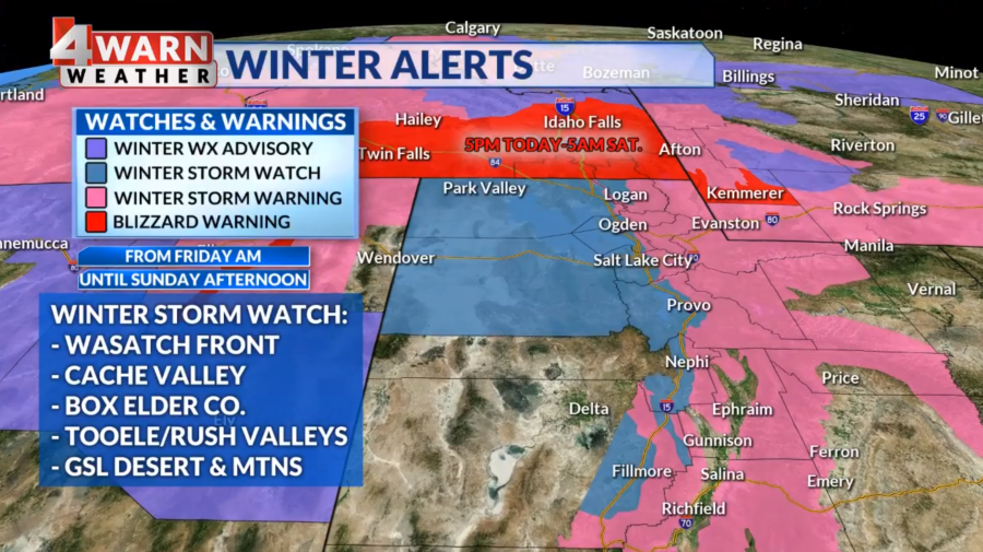
For the northern and central valleys, moderate snowfall is expected, and a winter storm watch is in effect from Friday morning through Sunday afternoon.
This watch will likely evolve into a winter weather advisory for parts of northern and central Utah ahead of the storm, Brophy said.
The Friday Commute
The first of the storms is set to hit Friday, with snow falling by the afternoon and evening in northern Utah valleys. Heavier snow is expected in the evening, and roads could become caked with snow during the late commute, especially along the northern Wasatch Front.
UDOT is advising drivers along the northern Wasatch Front, the Wasatch Back and the Uinta Basin to be prepared for major travel impacts. The travel forecast calls for blowing snow Friday night through Saturday morning.

According to Brophy, the snow from Friday’s storm could leave the northern and central valleys with anywhere from 1 to 4 inches of snow. The benches might see 3 to 6 inches, and mountain valleys could see up between 6 to 12 inches.
For mountains underneath the winter storm warning, 10 to 20 inches are expected through Saturday morning, and the Cottonwoods could get as much as and additional 1 to 2 feet of snow.
Remember, these totals are just through Saturday morning; another massive wave of moisture will move into Utah Saturday night.
Saturday into Sunday
Heavy snow takes aim at Utah Saturday night into Sunday, and weather models are hinting at some very high snow totals.
This storm could add another 4 to 10 inches to valleys in northern and central Utah, an additional 8 to 16 inches to the benches, another 10 to 20 inches for mountain valleys, and a whopping 15 to 30 inches to the mountains.
Such heavy snow would help bolster snowpack and boost our snow-water equivalent, or SWE, in parts of the state, Brophy said.
Avalanche warnings in effect as Utah mountains get hit by back-to-back storms
Avalanche danger is already ranked as “high” by the Utah Avalanche Center, but this type of accumulation could bring that threat to “extreme” and prompt an avalanche warning for certain parts of our mountain ranges.
“There’s always pro and cons to living in among our majestic mountains, and while we are all excited to recreate and enjoy the fresh snow, safety has to be top of mind,” Brophy said. “The last thing you want to see is sliding snow injuring or killing a Utahn just trying to enjoy the outdoors.”
For the latest news, weather, sports, and streaming video, head to ABC4 Utah.
Signup bonus from