What avalanche dangers do you face when skiing or snowboarding in California’s Sierra Nevada?
Depending on the weather and terrain, conditions in the mountains can range from “generally safe” to “extraordinarily dangerous,” according to the avalanche forecast website Avalanche.org.
On Wednesday morning, an avalanche in the popular Palisades Tahoe ski resort killed one person and injured three others.
The avalanche was triggered in the GS gully area of KT-22, an expert-level chair lift that serves steep terrain, The Sacramento Bee reported.
So how do you determine avalanche danger in an area?
How is avalanche danger determined?
The website Avalanche.org, a partnership between the American Avalanche Association and the Forest Service’s National Avalanche Center, serves as a hub for avalanche information and forecasts in the United States.
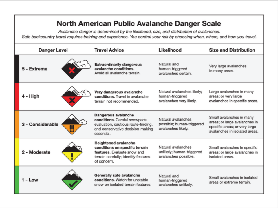
A color-coded map on the website provides daily avalanche forecasts for places around the United States based on the North American Public Avalanche Danger Scale, which looks at the likelihood, size and distribution of expected avalanches.
“We don’t forecast for every mountain range in the US, but we forecast for most of the places that get a lot of recreation,” said Simon Trautman, director of the National Avalanche Center in Bellingham in Washington state. “During the winter season, there are people that spend 50% of their time in the office and about 50% of their time in the field.”
According to Avalanche.org, the North American Public Avalanche Danger Scale consists of five levels ranging from the least to the highest amount of danger.
“Although the danger ratings are assigned numerical levels, the danger increases exponentially between levels,” the website said. “In other words, the hazard rises more dramatically as it ascends toward the higher levels on the scale.”
On the online avalanche forecast map, which is updated every 24 hours, the color black indicates extreme avalanche danger while red indicates high danger, while orange indicates considerable danger and yellow indicates moderate danger. Green means low danger.
How does North American Public Avalanche Danger Scale work?
Here are the different levels of the North American Public Avalanche Danger Scale and what they mean.
Level one signals low avalanche danger on the mountain and means the mountain is “generally safe,” according to Avalanche.com. Although danger is low, officials stressed, people out on the mountain should still be cautious when entering steep slopes.
Level two indicates heightened avalanche conditions on specific terrain, meaning small avalanches in specific areas or large avalanches in isolated areas, according to the avalanche website. Visitors should evaluate snow conditions and terrain carefully before exploring that area, as human-triggered avalanches are possible at this level.
At level three, there are considerable avalanche conditions and many slopes should be avoided. Natural avalanches are possible and human-triggered avalanches are likely, according to Avalanche.com, including “small avalanches in many areas” or “large avalanches in specific areas.”
At this level, “Avalanches may be less widespread, smaller or less likely” than under high avalanche danger, the website said.
Level four indicates high avalanche conditions. Travel in avalanche terrain w not recommended as it’s “very sensitive to human triggers,” Avalanche.com said, noting that large or very large natural and human-triggered avalanches are likely at this level.
Level five signals extreme, or, extraordinarily dangerous avalanche conditions. At this level, “Natural and human-triggered avalanches (are) certain,” including “very large avalanches in many areas,” according to forecasters.
What’s the avalanche forecast for California mountains?
The avalanche danger for a particular spot is dynamic, meaning that it can change from hour to hour day to day, Trautman said.
“It’s really important to know where on the scale (that location) is,” he said.
On Thursday, the avalanche forecast for the Central Sierra Nevada, which covers the Tahoe area, indicated considerable danger, according to Avalanche.com. The forecast was valid from 6:52 a.m. Thursday to 6:52 a.m. Friday.
On Wednesday, the avalanche danger in the Central Sierra Nevada was also considerable.
The Eastern Sierra Nevada, which covers the Mammoth area, and the Mount Shasta area also had forecast indicating considerable avalanche danger on Thursday.
What do you want to know about life in Sacramento? Ask our service journalism team your top-of-mind questions in the module below or email servicejournalists@sacbee.com.
Signup bonus from