A rinse and repeat weather pattern is in play across the South, which will lead to heavy rainfall, gusty winds, and possible tornadoes through the end of the workweek.
The storm system is similar to the event that impacted the region earlier in the week, with some of the same communities under a heightened risk for severe storms.
On the storm system’s northern end, snowfall and gusty winds will lead to problems along the I-80 corridor, while severe storms will be centered around Interstate 10 along the Gulf Coast and I-95 along the Atlantic seaboard.
The radar picture across the South is mostly clear, as thunderstorms are expected to develop during the late evening.
The late arrival of the storm system will allow the atmosphere to become more unstable and support thunderstorm development.
Storms are expected to develop over East Texas and move in an eastward trajectory towards Arkansas and Louisiana overnight.
“Normally, when you see severe weather, you lose some of that energy and the instability in the atmosphere overnight, and it could wane. That’s not going to be the case because of a low-level jet stream, something similar that played out on Monday into Tuesday night,” said FOX Weather meteorologist Steve Bender.
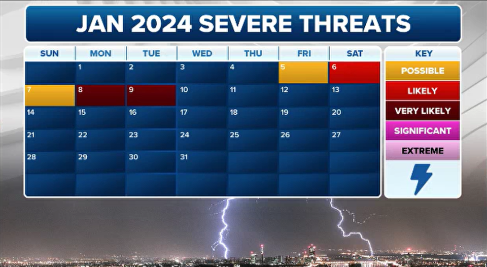
While Thursday’s threat is a level 2 out of 5, Friday’s risk increases to a level 3 out of 5 and includes a more expansive territory.
The FOX Forecast Center expects thunderstorms to be ongoing from Thursday evening and redevelopment to happen over the South that could lead to damaging wind gusts and tornadoes.
Friday’s target zone runs from east of the Mississippi River through the Carolinas and includes the Florida Panhandle.
Severe storms will be possible in Atlanta; Tallahassee, Florida; Columbia, South Carolina; Charlotte and Raliegh, North Carolina.
Forecasters warn that due to the available instability the atmosphere could be conducive for more supercell thunderstorm development than what was experienced earlier in the week, which featured more of a linear storm structure.
Discrete cells are known to have the potential to produce stronger tornadoes than those associated with squall lines, which generally lead to more widespread wind damage.
“This plays out as a very expansive threat – from the Mississippi River all the way up through the Carolinas – Thursday night into Friday,” said Bender.
The severe weather is expected to push off the East Coast by sunrise Saturday morning.
DEADLY STORMS SWEEP ACROSS SOUTH WITH EXTENSIVE TORNADO DAMAGE
Through nearly the first two weeks of the year, the amount tornadoes and damaging wind reports are above average.
The Storm Prediction Center has received 25 preliminary reports of twisters and over 300 reports of significant wind gusts.
Most of the reports are from a winter storm system that impacted the Southeast over the last week with an extensive squall line.
The thunderstorms produced wind gusts of hurricane-force and tornadoes that ranked as powerful as EF-3 on the Enhanced Fujita Scale.
So far, half the days of January have had some type of severe threat outlined over the Lower 48.
An active start to the year’s severe weather season is not an indication that the entire year will remain dynamic.
El Niño weather patterns are known to produce severe weather outbreaks across Florida and parts of the South during the winter months.
Original article source: Winter storm threat: Breakdown of severe weather forecast across South
Signup bonus from


