Sub-freezing temperatures will be widespread in the Central San Joaquin Valley again Monday night and more snowfall is headed for the higher regions in the Sierra Nevada.
That’s the word from the National Weather Service in Hanford, after Fresnans awoke Monday morning to frost on rooftops and ice on car windshields.
Jim Bagnall, a meteorologist with the weather service in Hanford, said the thermometer will dip to the low 30s Monday night in urban areas like Fresno, and will go as low as 28 degrees in outlying regions Monday night and Tuesday morning.
A Freeze Warning remains in effect for the San Joaquin until 8 AM PST Tuesday morning. A Freeze Warning means that sub-freezing temperatures are imminent or highly probable. Bring pets indoors and cover sensitive, exposed vegetation. #CAwx pic.twitter.com/TQKEuk6RO1
— NWS Hanford (@NWSHanford) January 8, 2024
Fresno’s high Monday was expected to be 53, with a low of 39.
While chilly, the temperatures aren’t likely to be cold enough to damage most plants or trees, including frost-sensitive citrus, according to the University of California Cooperative Extension in Merced.
According to the extension, most citrus can tolerate temperatures to 26 degrees or even lower.
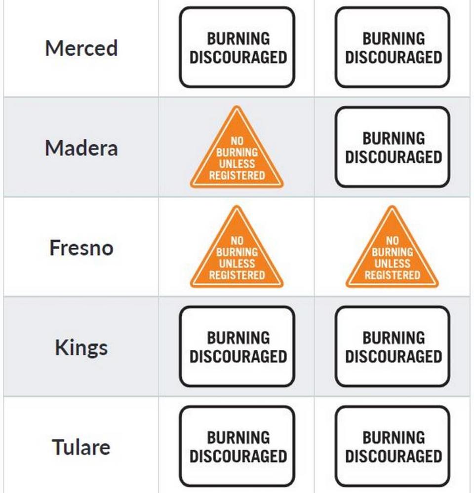
While the low temperatures may temp some to light up the fireplace, the San Joaquin Valley air pollution district is cautioning that only residents with permitted devices are allowed to do so.
Bagnall, of the weather service, said that the next weather front moving in from the Pacific Northwest should begin to arrive in the Central San Joaquin Valley by Wednesday. Up to a foot of new snow may fall in higher elevations.
In contrast to early 2023, rainfall for the region remains below normal. So far in the season that began Oct. 1 and runs to Sept. 30, the total stands at 1.42 inches. The normal for Jan. 8 is 2.31 inches
Signup bonus from