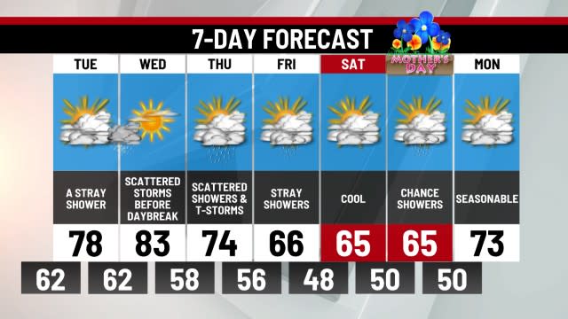
THIS AFTERNOON/EVENING: Snow & Sleet, Breezy. Hi 35. Winds: E 5-15 mph.
TONIGHT: Lingering Snow Showers. Lo 33. Winds: NE 5-15 mph.
SUNDAY: Snow Showers, Breezy. Hi 41. Winds: W 5-15 mph.
The first major winter storm of the season is upon Central PA as the weekend begins. Cold air is firmly in place and the storm that will bring a quick hit of heavy snow, mix, and rain to the region today is advancing toward Pennsylvania. Here is the latest and final breakdown of this system:
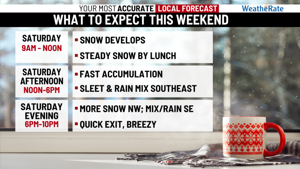
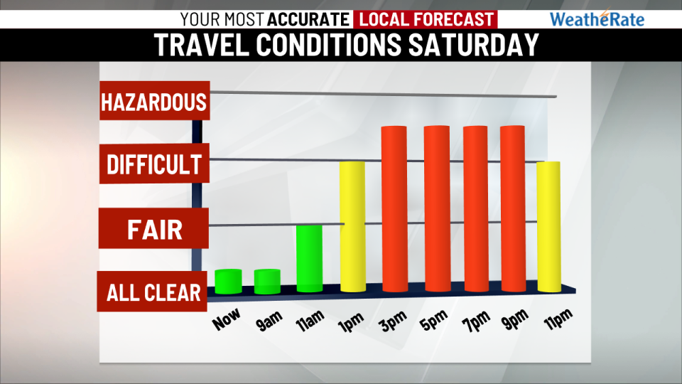
Early afternoon update: Snow has developed across the entire Midstate, with the heaviest snow far located over the Cumberland Valley including South Mountain and Franklin County. Periods of heavy snow will continue to overspread much of the region with the brunt of it will occurring between Noon-6pm. By 10pm, the storm is done. It is a quick-moving storm that will put down a burst of accumulating snow, followed by sleet and even rain in southern and eastern areas before it wraps up during the late evening. It will bring plowable snow to parts of the region, but it will be manageable. Let’s break it down:
Again the bulk of the storm will occur now through 6pm with steady snow for most areas, while southeastern areas will see sleet and even rain take over during this time. Very little snow accumulation is expected for areas across our extreme southeast counties. For most areas, this will bring a plowable but manageable snowfall of 2-5″, especially for the Cumberland Valley and Capital Area Beltway. The ridge and valley region and South Mountain are the locations where we expect to see the most snow. Areas farther to the north and west will see 5-8″ of snow. There is going to be a thin but intense band of snow setting up somewhere across the region where snowfall rates could be 1-2″ per hour at the height of this storm. This band could set up anywhere from Harrisburg to just north and west of the city. Wherever this band occurs will likely see the highest totals from this storm. The storm will mix with sleet and rain this evening for many in the east before it rapidly exits. By 10pm tonight, the storm is over. It will be a 12-hour storm with the brunt of accumulation taking place over a 6-hour stretch from Noon-6pm.
Here is the latest snow total forecast and storm timeline:

Whatever snow the region picks up won’t last long. By next week after a brief respite on Monday, another storm takes aim at the region on Tuesday. Lows Tuesday morning will be in the 20s and that means this next storm could start as a brief mix of snow and sleet before plenty of warm air rushes in and changes everything to rain. Most of the storm will be rain with highs near 50° on Tuesday. Up to 1″ of rain is expected at this time. We will keep watching this next storm as well. Stay tuned for updates about all of this through the weekend.
-Meteorologists Brett Thackara and Dan Tomaso
For the latest news, weather, sports, and streaming video, head to ABC27.
Signup bonus from


