Snow is headed back into the area this weekend, bringing the threat of icy spots, especially late Saturday and early Sunday.
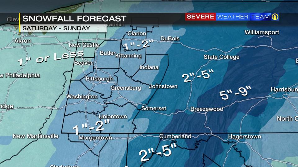
The latest Severe Weather Team 11 forecast has snow starting south of I-70 early Saturday and then developing north into Pittsburgh, Washington, and Greensburg by mid-morning. Cranberry, Butler and Indiana will see snow by noon or early afternoon.
A period of steady snow is possible after lunch through the afternoon with a slushy accumulation possible, but most roads will be mainly wet during the day. Snow will taper to snow showers before sunset on Saturday, but icy spots will be possible on untreated surfaces as temperatures fall. Watch for slick spots late Saturday and early Sunday.
Scattered snow showers will continue Sunday with snowfall totals of 1″-3″ for most areas and higher amounts east of Pittsburgh. Changes to the forecast and snowfall totals are still possible so check the Severe Weather Team 11 live updates in every newscast as this storm develops and alerts on the Severe Weather Team 11 app.
Download the FREE WPXI News app for breaking news alerts.
Follow Channel 11 News on Facebook and Twitter. | Watch WPXI NOW
TRENDING NOW:
‘Code Blue’ in effect for Allegheny County, City of Pittsburgh starting Thursday night Monroeville police officer shot by Crumbl Cookie armed robbery suspect Lawmaker wants to end City of Pittsburgh’s ‘sanctuary city’ status, ban designation statewide VIDEO: Hundreds gather to honor fallen Brackenridge Police Chief Justin McIntire DOWNLOAD the Channel 11 News app for breaking news alerts
Signup bonus from