NEW YORK – FOX Weather meteorologists are tracking what’s expected to become the first major winter storm of 2024, which could bring the first significant snow in two years for several cities along the East Coast and flooding rain to the South, all translating to messy weekend travel across the eastern U.S.
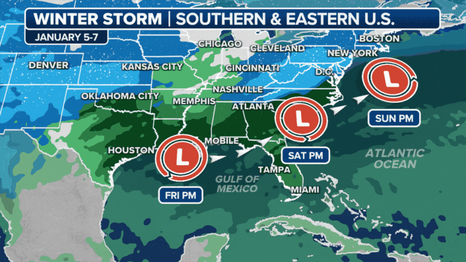
The storm is forecast to develop Friday along the Gulf Coast. While computer forecast models still vary widely on snow and rain amounts and the actual track and strength of the storm, the FOX Forecast Center is keeping an eye on key takeaways that will spell out dangerous and slow travel conditions:
-
An area of low pressure will develop late Friday and move up the East Coast.
-
Heavy rain and gusty winds will likely create significant travel disruptions for the South.
-
Confidence is increasing for impactful snowfall in the mid-Atlantic and Northeast. Parts of the Interstate 95 corridor could see over an inch.
This nearly two-year streak without an inch of snow for Philadelphia smashed the previous record streak of 661 days without an inch of snow that ended in 1973. New York City long-ago clobbered the old record of 383 days without an inch of snow that ended in 1998.
New York City only saw 2.3 inches of snow over the winter of 2022 through all of 2023. That is more than a 2-foot deficit compared to the average winter season snowfall and a record for the lowest annual snowfall total.
Philadelphia and Washington both saw less than a half-inch, leaving those cities with a 22.8-inch and 13.3-inch deficit, respectively. Even cities that saw snow got only a fraction of what they typically see. Boston saw 49.2 inches of snow over the 2022-23 winter, more than 3 feet less than average.
NEW YORK, PHILADELPHIA BREAKING RECORDS FOR LACK OF SNOW IN NORTHEAST

The FOX Forecast Center is tracking what appears to be the first noteworthy winter storm of the new year this weekend and into early next week, set to impact at least 20 states from Texas to New England.
The Gulf Coast could see days of heavy rain, triggering flood concerns. The Interstate 10 and 20 corridors and southern portions of the I-95 corridor will deal with wet pavement.
The storm will then slide northward near or off the East Coast as it collides with the cold air. Anyone living from Kentucky to New England could be in for heavy snow.
“There is still some disagreement, and we’re watching to see what ends up happening,” FOX Weather Meteorologist Kendall Smith said. “But the overall thought process is that if you live in a higher-elevation region, so potentially the Appalachian Mountains, that’s an area where you could see some heavy snow. Also, the Catskills, that’s an area where we could see some heavy snow.”
Smith cautioned that it’s far too early to make any sort of prediction for exact snowfall totals since the winter storm is still several days away. However, the odds continue to increase that at least some parts of the I-95 corridor could pick up measurable snow, particularly on Sunday.
WINTER STORM WARNING CRITERIA FOR US REVAMPED BY NATIONAL WEATHER SERVICE
An area of low pressure is expected to develop between Houston and New Orleans on Friday, producing heavy rain along the Gulf Coast. Flash flooding is possible from southeastern and eastern Texas eastward to the Florida Panhandle.
HOW THUNDERSTORMS HUNDREDS OF MILES AWAY CAN WREAK HAVOC ON AIR TRAVEL
On Saturday, the low-pressure system is forecast to plow east as it organizes and strengthens. Check with your airline if you are flying into or out of Atlanta, the world’s busiest airport, as the heavy rain and gusty winds could create delays, especially in the morning.
The FOX Forecast Center also warns of the possibility of severe storms in Florida on Saturday afternoon and evening.
By late Saturday, the powerful winter storm will likely be located over the Carolinas, where it will begin to meet up with cold air. Rain is expected to transition to snow across West Virginia, Pennsylvania and Virginia, but questions remain about how quickly this changeover occurs.
WHAT ARE THE WORST AIRPORTS TO FLY INTO DURING WINTER?
The storm is predicted to push off the East Coast near the Carolinas and continue to head north on Sunday.
Heavy snow is possible across parts of Pennsylvania and upstate New York. There’s also the potential for snow along the I-95 corridor from Washington and Baltimore to Philadelphia and New York City, though significant uncertainty remains in the forecast.
Regardless, the FOX Forecast Center says this is by far the best chance for accumulating snow these major East Coast cities have seen in nearly two years.
WHEN IS THE FIRST SNOW OF THE SEASON?
By Monday morning, the winter storm will be pulling away from the Northeast, ushering in a dry start to the workweek and providing an opportunity to clear the snow from roads, driveways and sidewalks.
Snow-lovers should feel hopeful about the weekend, even several days out, because the current storm track is promising. We have to look back to late-January 2022 to find the last notable snowstorm for the I-95 corridor. On Jan. 28-29, 2022, a nor’easter buried parts of the region under snow and even touched off blizzard conditions.
Cold air in place in 2022 turned all precipitation to snow. Delaware and eastern New Jersey not only saw over a foot of snow, but winds gusting between 50 and 60 mph blew around the snow, turning the storm into a blizzard, according to the National Weather Service. Blizzard conditions pushed into New England on the 29th.
Boston measured 23.8 inches of snow. New York City saw 8.5 inches, while Baltimore got 1.5 inches.
BLIZZARD OF ’22 PRODUCES HURRICANE-FORCE WINDS, DUMPS FEET OF SNOW IN NEW ENGLAND
Original article source: First major winter storm of 2024 could bring first significant snow in 2 years from New York to Washington
Signup bonus from