Southern California’s weather is about to take a turn for the wet.
An atmospheric river event will arrive on Sunday and bring the potential for rain each day through next week, meteorologists say.
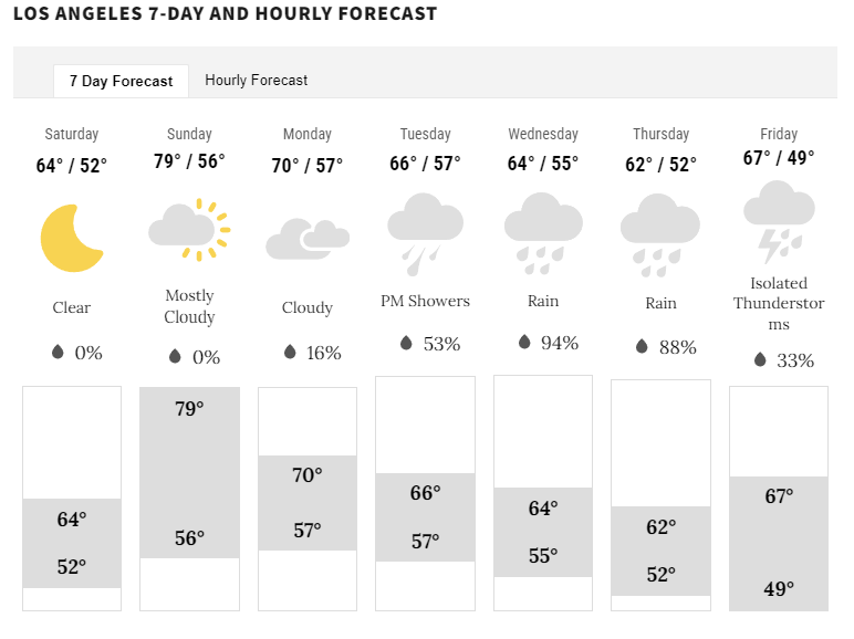
The first and the weaker of two storms arrives on Sunday and, according to the National Weather Service, will bring light rain to the Central Coast and into Ventura County through Monday.
Los Angeles County is expected to see little to no rainfall at first.
The low-pressure “event,” however, will bring more widespread rain to a broader area starting on Wednesday, says KTLA 5 weather anchor Kaj Goldberg.
“At that point, the next wave of energy arrives and we’ll have a much greater chance of substantial, measurable rainfall and even thunderstorms in Southern California,” Goldberg says.

The likelihood of rain extends from the coastal areas throughout the Los Angeles Basin and to the Inland Empire and continues into the weekend.
“We will be on storm watch Monday through next Saturday before the skies clear and we start to dry out,” Goldberg says.
Here are the anticipated rainfall totals for Monday through Saturday:
-
Coasts/Basin = 1.00” to 2.50”
-
Valleys/Foothills = 2.00” – 3.50”
-
Mountains = 3.00” – 4.00″
Goldberg says the rain could produce localized street flooding.
Snow levels throughout the atmospheric river will remain very high, generally above 7,000 feet, the NWS said.
For the latest news, weather, sports, and streaming video, head to KTLA.
Signup bonus from


